Category:Theresienstraße B 195 (Neuburg an der Donau)
Jump to navigation
Jump to search
This is the category of the Bavarian Baudenkmal (cultural heritage monument) with the ID D-1-85-149-191 (Wikidata)
|
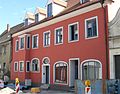
Deutsch: Wohn- und Geschäftshaus, sogenanntes Reiterbauernhaus. Zweigeschossiger traufseitiger Bau mit Ladeneinbau und Bodenerker, im Kern 17. Jahrhundert, Änderung der Hauptfirstrichtung im 19. Jahrhundert.
Theresienstraße B 195, Neuburg an der Donau, Bayern, Deutschland
Theresienstraße B 195, Neuburg an der Donau, Bayern, Deutschland
| Object location | | View all coordinates using: OpenStreetMap |
|---|
building in Neuburg an der Donau, Upper Bavaria, Germany  | |||||
| Upload media | |||||
| Instance of | |||||
|---|---|---|---|---|---|
| Location | Neuburg an der Donau, Neuburg-Schrobenhausen, Upper Bavaria, Bavaria, Germany | ||||
| Street address |
| ||||
| Heritage designation | |||||
 | |||||
Media in category "Theresienstraße B 195 (Neuburg an der Donau)"
The following 4 files are in this category, out of 4 total.
-
 Neuburg Theresienstraße B 195 (01).jpg 4,928 × 3,264; 6.51 MB
-
 Neuburg Theresienstraße B 195 (02).jpg 4,928 × 3,264; 6.55 MB
-
 Neuburg Theresienstraße B 195 und 194a.jpg 4,928 × 3,264; 7.12 MB
-
 Theresienstr. B195 Neuburg-1.jpg 2,391 × 1,863; 634 KB
.jpg)
.jpg)
