Category:Thingwall Road Flow Measurement Station
Jump to navigation
Jump to search
| Object location | | View all coordinates using: OpenStreetMap |
|---|
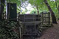
Gauging station on the Arrowe Brook on Thingwall Road, Irby, operated by the Environment Agency.
Media in category "Thingwall Road Flow Measurement Station"
The following 3 files are in this category, out of 3 total.
-
 Thingwall Road Flow Measurement Station 1.jpg 4,916 × 2,784; 8.24 MB
-
 Thingwall Road Flow Measurement Station 2.jpg 4,884 × 3,104; 9.91 MB
-
 Thingwall Road Flow Measurement Station 3.jpg 5,028 × 3,292; 10.48 MB


