Category:Tirschenreuth
Jump to navigation
Jump to search
municipality of Germany      | |||||
| Upload media | |||||
| Pronunciation audio | |||||
|---|---|---|---|---|---|
| Instance of |
| ||||
| Part of |
| ||||
| Location | Tirschenreuth, Upper Palatinate, Bavaria, Germany | ||||
| Population |
| ||||
| Area |
| ||||
| Elevation above sea level |
| ||||
| official website | |||||
 | |||||

Čeština: Tirschenreuth je hlavní město zemského okresu Tirschenreuth. Nachází se na severovýchodě Bavorska, velmi blízko hranic s Českou republikou.
Deutsch: Tirschenreuth ist eine Stadt in Bayern. Sie befindet sich in der Oberpfalz am Fluss Waldnaab nahe der Deutsch-Tschechischen Grenze.
English: Tirschenreuth is a town in Bavaria, Germany. It is located in the Upper Palatinate on the river Waldnaab, close to the Czech-German border.
Français : Tirschenreuth est une ville allemande située en Bavière et chef-lieu de l'arrondissement de Tirschenreuth.
Nederlands: Tirschenreuth is een plaats in de Duitse deelstaat Beieren, gelegen in het district Tirschenreuth.
Русский: Тиршенройт — город в Германии, на реке Вальднаб, районный центр, расположен в земле Бавария.
Subcategories
This category has the following 20 subcategories, out of 20 total.
!
B
C
E
F
H
- History of Tirschenreuth (25 F)
M
- Maps of Tirschenreuth (1 F)
N
P
R
- Rosall (2 F)
S
- Symbols of Tirschenreuth (5 F)
T
V
- Views of Tirschenreuth (7 F)
W
- Wolfenstein (Tirschenreuth) (2 F)
- Wondrebhammer (1 F)
Media in category "Tirschenreuth"
The following 57 files are in this category, out of 57 total.
-
 2019 Hamm.jpg 4,608 × 2,592; 4.75 MB
-
 2019 Hamm01.jpg 4,608 × 2,592; 5.88 MB
-
 2019 Tirschenreuth Himmelsleiter01.jpg 4,608 × 2,592; 6.94 MB
-
 2019 Tirschenreuth Himmelsleiter02.jpg 3,840 × 1,088; 2.05 MB
-
 2019 Tirschenreuth Himmelsleiter03.jpg 4,608 × 2,592; 7.26 MB
-
 2019 Tirschenreuth Marktplatz 01.jpg 4,608 × 2,592; 6.38 MB
-
 2019 Tirschenreuth Marktplatz.jpg 3,840 × 1,088; 3.11 MB
-
 AK - Tirschenreuth - 1920.jpg 1,640 × 2,130; 2.07 MB
-
 AK - Tirschenreuth - Bärnau - Vogelschau - Felle - 1918.jpg 1,200 × 774; 198 KB
-
 AK - Tirschenreuth - Bärnau - Vogelschau - Felle - 1919.jpg 2,000 × 1,282; 2.01 MB
-
 AK - Tirschenreuth - Bärnau - Vogelschau - Felle.jpg 1,200 × 792; 158 KB
-
 Aussichtsbank bei Neuenreuth - panoramio.jpg 4,608 × 3,456; 8.71 MB
-
 Bahn-Farradweg von Tirschenreuth in Richtung Schmellitz - panoramio.jpg 2,048 × 1,536; 1.35 MB
-
 Bank am Bürgerwaldweg - panoramio.jpg 4,608 × 3,456; 8.42 MB
-
 Bank am Weha-Weg - panoramio.jpg 4,608 × 3,456; 8.3 MB
-
 Barttasse, Tirschenreuth um 1880.jpg 3,004 × 2,875; 2.96 MB
-
 Bei Grünberg - panoramio.jpg 1,600 × 1,200; 449 KB
-
 Bergkreuz Kastler Berg - panoramio.jpg 4,608 × 3,456; 9.59 MB
-
 Blick zur Kösseinne - panoramio.jpg 4,608 × 3,456; 8.4 MB
-
 Burgstall Lengenfeld.jpg 2,592 × 1,936; 2.21 MB
-
 Burgstall Rosall.PNG 793 × 432; 691 KB
-
 Burgstall Rothenbürg-neu.PNG 480 × 423; 446 KB
-
 Burgstall Rothenbürg.PNG 814 × 412; 671 KB
-
 Corona Testzentrum Schild Tirschnreuth - 2021.jpg 8,000 × 6,000; 16.17 MB
-
De-Tirschenreuth.ogg 2.2 s; 21 KB
-
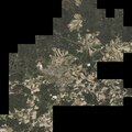 Digitales Orthofoto von Tirschenreuth (Bayerische Vermessungsverwaltung).tif 37,500 × 37,500; 2.5 GB
-
 Dreifaltigkeitssäule.JPG 1,694 × 2,321; 2.54 MB
-
 Fichtelnaab - panoramio.jpg 1,600 × 1,200; 571 KB
-
 Fischerbrunnen - panoramio (3).jpg 4,608 × 3,456; 10.27 MB
-
 Flurbereinigungsdenkmal Kastl - panoramio.jpg 4,608 × 3,456; 10.66 MB
-
 Fuhrbach - panoramio.jpg 1,600 × 1,200; 403 KB
-
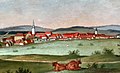 Gemälde - Ansicht von Tirschreuth - um 1830.jpg 1,000 × 611; 474 KB
-
 Herrnweiher 1 - panoramio.jpg 4,608 × 3,456; 9.12 MB
-
 Herrnweiher 2 - panoramio.jpg 4,608 × 3,456; 7.35 MB
-
 Himmelsleiter im Abendlicht.jpg 1,536 × 2,048; 1.55 MB
-
 Jäger&Turba.JPG 2,296 × 1,344; 1.82 MB
-
 Kammerwagen - panoramio.jpg 3,456 × 4,608; 10.22 MB
-
 Kriegerdenkmal 1. WK - panoramio.jpg 3,456 × 4,608; 9.94 MB
-
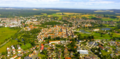 Luftbild Tirschenreuth Oberpfalz.png 1,632 × 798; 2.63 MB
-
 Luftbild Tuchfabrik Mehler in Tirschenreuth.png 1,008 × 551; 1.06 MB
-
 Marktplatz TIR redevelopment July 2008.jpg 1,024 × 768; 469 KB
-
 Marterl bei Reuth - panoramio.jpg 4,608 × 3,456; 9.9 MB
-
 Marterl-Pfahl - panoramio.jpg 3,456 × 4,608; 9.6 MB
-
 Oberölbühler Weiher - panoramio.jpg 1,600 × 1,200; 344 KB
-
 Postcard Tirschenreuth 1901.jpg 464 × 262; 58 KB
-
 RBO-BusTIR.jpeg 2,385 × 1,433; 644 KB
-
 Siegel der Lengenfelder 1335.jpg 840 × 1,188; 318 KB
-
 Sparkasse Tirschenreuth.JPG 2,528 × 1,648; 2.43 MB
-
 Stiftland-Gymnasium Tirschenreuth am 8. Mai 2018.jpg 5,920 × 2,900; 3.6 MB
-
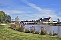 Tirschenreuth - Barocke Fischhofbrücke.JPG 6,000 × 4,000; 13.94 MB
-
 Tirschenreuth - Fischhofpark.jpg 11,700 × 3,816; 50.25 MB
-
 Tirschenreuth 2009 - Brunnen am unt. Marktplatz - panoramio.jpg 2,112 × 2,816; 2.78 MB
-
 Tirschenreuth 2009 - Rathaus am ob. Marktplatz - panoramio.jpg 2,816 × 2,112; 2.49 MB
-
 Tirschenreuth aus Richtung Südwesten - panoramio.jpg 2,048 × 1,536; 1.47 MB
-
 Tirschenreuth, Kriegerdenkmal 2.jpg 4,608 × 3,456; 10 MB
-
 Tirschenreuth, Schmeller Büste.JPG 2,175 × 3,000; 998 KB
-
 Tirschenreuther Rathaus.jpg 2,824 × 2,235; 2.46 MB


.jpg)


