Category:Tonberg Kleinragewitz
Jump to navigation
Jump to search
| Object location | | View all coordinates using: OpenStreetMap |
|---|
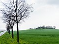
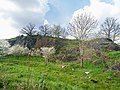
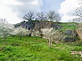
hill and natural monument area in Liebschützberg Municipality, Saxony, Germany  | |||||
| Upload media | |||||
| Instance of | |||||
|---|---|---|---|---|---|
| Location | Kleinragewitz, Liebschützberg, Nordsachsen, Saxony, Germany | ||||
| Heritage designation |
| ||||
| Area |
| ||||
| Elevation above sea level |
| ||||
 | |||||
Media in category "Tonberg Kleinragewitz"
The following 8 files are in this category, out of 8 total.
-
 Kleinragewitz Tonberg-01.jpg 5,333 × 3,333; 4.57 MB
-
 Kleinragewitz Tonberg-02.jpg 5,215 × 3,911; 9.21 MB
-
 Kleinragewitz Tonberg-03.jpg 4,000 × 6,000; 10.56 MB
-
 Kleinragewitz Tonberg-04.jpg 5,333 × 4,000; 10.11 MB
-
 Kleinragewitz Tonberg-05.jpg 5,333 × 4,000; 13.27 MB
-
 Kleinragewitz Tonberg-06.jpg 5,333 × 4,000; 11.76 MB
-
 Kleinragewitz Tonberg-07.jpg 5,333 × 4,000; 13.3 MB
-
 Kleinragewitz Tonberg.jpg 5,096 × 3,822; 7.54 MB


