Category:Topographic maps of Kanagawa prefecture
Jump to navigation
Jump to search
English: Category for the topographic maps of Kanagawa Prefecture, Japan
日本語: 日本・神奈川県に関する地形図のカテゴリ
| Prefectures of Japan 地形図 (Topographic map) | |||
|---|---|---|---|
|

| ||
Media in category "Topographic maps of Kanagawa prefecture"
The following 4 files are in this category, out of 4 total.
-
 Ashigara Plain Relief Map, SRTM-1.jpg 1,000 × 1,000; 648 KB
-
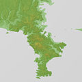 Miura Peninsula Relief Map, SRTM-1.jpg 1,600 × 1,600; 806 KB
-
 Mount Ōyama (Kanagawa) Relief Map, SRTM-1.jpg 800 × 600; 363 KB
-
 Tanzawa Mountains 20121119.jpg 2,400 × 1,600; 2.97 MB


_Relief_Map,_SRTM-1.jpg)
