Category:Topographisch-historische Ansicht der Belagerung Kopenhagens (1807)
Jump to navigation
Jump to search
Deutsch: Topographisch-historische Ansicht der Belagerung Kopenhagens. (1807) by LAHDE
| This category includes images from a book scanned for the British Library Mechanical Curator collection.
The full set of images from the book is available on Flickr. |
1807 edition of book by Gerhard Ludvig Lahde and Rasmus Nyerup | |||||
| Upload media | |||||
| Instance of |
| ||||
|---|---|---|---|---|---|
| Author | |||||
| Place of publication |
| ||||
| Distribution format |
| ||||
| Full work available at URL | |||||
| Collection | |||||
| Publication date |
| ||||
| |||||
Media in category "Topographisch-historische Ansicht der Belagerung Kopenhagens (1807)"
The following 3 files are in this category, out of 3 total.
-

-
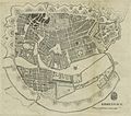 LAHDE(1807) p025 Plan von Kopenhagen.jpg 2,943 × 2,589; 4.28 MB
-
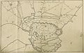 LAHDE(1807) p027 Plan der Umgebung von Kopenhagen.jpg 3,149 × 2,006; 3.07 MB
_Topographisch-historische_Ansicht_der_Belagerung_Kopenhagens.jpg)
_p025_Plan_von_Kopenhagen.jpg)
_p027_Plan_der_Umgebung_von_Kopenhagen.jpg)