Category:Topographischer Atlas des Königreichs Hannover und des Herzogtums Braunschweig
Jump to navigation
Jump to search
 | |||||
| Upload media | |||||
| Instance of |
| ||||
|---|---|---|---|---|---|
| Depicts | Kingdom of Hanover and Duchy of Brunswick | ||||
| Creator | |||||
| |||||
Media in category "Topographischer Atlas des Königreichs Hannover und des Herzogtums Braunschweig"
The following 15 files are in this category, out of 15 total.
-
 1830 circa August Papen Plan Hannover, Ausschnitt Knochenhauer Feld.jpg 3,456 × 4,608; 5.13 MB
-
-
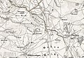
 Braunschweig West Karte.jpg 800 × 581; 416 KB
-
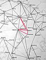 Dreieckssystem Breitehorn Gauß Landvermessung.jpg 1,232 × 1,612; 1.14 MB
-
 Dreieckssystem Falkenberg Gauß Landvermessung.jpg 965 × 1,287; 744 KB
-
 Dreieckssystem Haußelberg Gauß Landvermessung.jpg 1,232 × 1,612; 1.15 MB
-
 Dreieckssystem Lüneburg Gauß Landvermessung.jpg 1,129 × 1,127; 777 KB
-
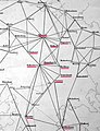 Dreieckssystem Lüneburger Heide Gauß Landvermessung.jpg 1,232 × 1,612; 1.13 MB
-
 Dreieckssystem Wilseder Berg Gauß Landvermessung.jpg 1,027 × 1,227; 716 KB
-
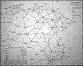 Dreieckssystem-Übersicht Gauß-Ausstellung Bomann-Museum (1).JPG 3,623 × 2,865; 5.41 MB
-

-
 Forstrevier Sophienthal Papen 2a.jpg 3,000 × 3,840; 4.17 MB
-

-

-


.JPG)


.jpg)

