Category:Torre Luengo
Jump to navigation
Jump to search
| Object location | | View all coordinates using: OpenStreetMap |
|---|
.jpg) | |||||
| Upload media | |||||
| Instance of | |||||
|---|---|---|---|---|---|
| Location | Alginet, Ribera Alta, Province of Valencia, Valencian Community, Spain | ||||
| Heritage designation | |||||
 | |||||
Català: Escut de la Torre Luengo (Alginet)
This is a category about a building listed in the Valencian heritage register as Bé de Rellevància Local (BRL) under the reference 46.20.031-003. |
Subcategories
This category has only the following subcategory.
Media in category "Torre Luengo"
The following 14 files are in this category, out of 14 total.
-
 0.1. La Torre Luengo (Alginet, País Valencià).jpg 4,920 × 2,755; 1.45 MB
-
 0.2. La Torre Luengo (Alginet, País Valencià).jpg 4,103 × 5,236; 14.11 MB
-
 Ceràmica de Manises (Rajola de València). Espai públic d'Alginet. Torre Luengo.jpg 1,298 × 1,084; 263 KB
-
 Fanguejar. Alginet, 1952 (País Valencià).jpg 6,017 × 3,767; 1.26 MB
-
 Hort Maria Rosa Dalmau (Torre Luengo).jpg 3,592 × 2,648; 455 KB
-
 Hort Maria Rosa Dalmau (Torre Luengo)2.jpg 3,360 × 2,608; 530 KB
-
 Hort Maria Rosa Dalmau.jpg 2,880 × 1,304; 329 KB
-
 Porta d'entrada a l'hort de la Torre Luengo.jpg 2,304 × 3,840; 523 KB
-
 Porta de la Torre Luengo.jpg 2,152 × 3,744; 635 KB
-
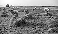 Segant arròs. Alginet, 1953 (País Valencià).jpg 6,608 × 3,888; 3.55 MB
-
 Torre Luengo (Alginet).jpg 2,393 × 2,736; 483 KB
-
 Torre Luengo 2 (Alginet).JPG 2,781 × 3,039; 662 KB
-
 Torre Luengo 2..jpg 3,776 × 2,664; 730 KB
-
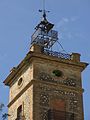 Torre Luengo.jpg 3,000 × 4,000; 792 KB
.jpg)
._Espai_p%C3%BAblic_d%27Alginet._Torre_Luengo.jpg)
.jpg)
.jpg)
2.jpg)


.jpg)
.jpg)
.JPG)

