Category:Tour Chappe de Marcy
Jump to navigation
Jump to search
| Object location | | View all coordinates using: OpenStreetMap |
|---|
|
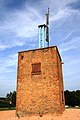
This building is inscrit au titre des monuments historiques de la France. It is indexed in the base Mérimée, a database of architectural heritage maintained by the French Ministry of Culture, under the reference PA00117994
|
semaphore tower in Marcy, France  | |||||
| Upload media | |||||
| Instance of |
| ||||
|---|---|---|---|---|---|
| Location | Marcy, Rhône, Auvergne-Rhône-Alpes, Metropolitan France, France | ||||
| Heritage designation |
| ||||
| Inception |
| ||||
 | |||||
Media in category "Tour Chappe de Marcy"
The following 6 files are in this category, out of 6 total.
-
 Beaujolais, Marcy, télégraphe Chappe, dabut 19e siècle.jpg 2,592 × 3,888; 3.97 MB
-
 Optical Chappe Telegraph Marcy France 2.jpg 2,206 × 3,067; 1.44 MB
-
 Optical Chappe Telegraph Marcy France.jpg 800 × 560; 130 KB
-
 Tour du télégraphe de Chappe de Marcy - Vue de côté.jpg 4,016 × 6,016; 12.81 MB
-
 Tour du télégraphe de Chappe de Marcy.jpg 4,016 × 6,016; 12.86 MB
-
 XDA PA00117994.jpg 1,200 × 1,807; 1.75 MB


