Category:Tour du Viala-du-Pas-de-Jaux
Jump to navigation
Jump to search
| Object location | | View all coordinates using: OpenStreetMap |
|---|
|
This building is inscrit au titre des monuments historiques de la France. It is indexed in the base Mérimée, a database of architectural heritage maintained by the French Ministry of Culture, under the reference PA00125562
|
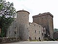
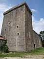
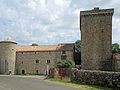
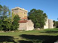
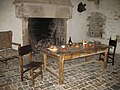
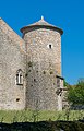
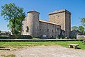
granary-tower sheltering the harvests of farms dependent from the commandery of Sainte-Eulalie de-Cernon  | |||||
| Upload media | |||||
| Instance of | |||||
|---|---|---|---|---|---|
| Location | Viala-du-Pas-de-Jaux, canton of Cornus | ||||
| Heritage designation |
| ||||
| Inception |
| ||||
| official website | |||||
 | |||||
| Tour du Viala-du-Pas-de-Jaux
|
|||
|---|---|---|---|
|
|||
| Native name | Tour du Viala-du-Pas-de-Jaux | ||
| Location | Le Viala-du-Pas-de-Jaux, Aveyron, France | ||
| Coordinates | | ||
| Established | 1430 | ||
| Website | www.burnley.gov.uk/towneley | ||
| Authority file |
| ||
Pages in category "Tour du Viala-du-Pas-de-Jaux"
This category contains only the following page.
Media in category "Tour du Viala-du-Pas-de-Jaux"
The following 41 files are in this category, out of 41 total.
-
 Tour du Viala-du-Pas-de-Jaux (12) - 01.jpg 4,000 × 3,000; 4.71 MB
-
 Tour du Viala-du-Pas-de-Jaux (12) - 02.jpg 3,000 × 4,000; 4.18 MB
-
 Tour du Viala-du-Pas-de-Jaux (12) - 03.jpg 3,000 × 4,000; 3.59 MB
-
 Tour du Viala-du-Pas-de-Jaux (12) - 04.jpg 4,000 × 3,000; 5 MB
-
 Tour du Viala-du-Pas-de-Jaux (12) - 05.jpg 4,000 × 3,000; 4.63 MB
-
 Tour du Viala-du-Pas-de-Jaux (12) - 06.jpg 4,000 × 3,000; 4.6 MB
-
 Tour du Viala-du-Pas-de-Jaux (12) - 07.jpg 4,000 × 3,000; 5.02 MB
-
 Tour du Viala-du-Pas-de-Jaux (12) - 08.jpg 4,000 × 3,000; 5.1 MB
-
 Tour du Viala-du-Pas-de-Jaux (12) - 09.jpg 3,000 × 4,000; 4.39 MB
-
 Tour du Viala-du-Pas-de-Jaux (12) - 10.jpg 4,000 × 6,000; 8.46 MB
-
 Tour du Viala-du-Pas-de-Jaux (12) - 11.jpg 6,000 × 4,000; 12.36 MB
-
 Tour du Viala-du-Pas-de-Jaux -1.JPG 4,896 × 3,672; 6.92 MB
-
 Tour du Viala-du-Pas-de-Jaux -2.JPG 3,672 × 4,896; 7.38 MB
-
 Tour du Viala-du-Pas-de-Jaux IMG 0059.jpg 2,576 × 1,932; 2.93 MB
-
 Tour viala 1.jpg 458 × 690; 110 KB
-
 Tour viala 2.jpg 458 × 690; 95 KB
-
 Tour-Viala-du-Pas-de-Jaux 1.JPG 3,648 × 2,736; 1.68 MB
-
 Tour-Viala-du-Pas-de-Jaux 2.JPG 3,648 × 2,736; 1.53 MB
-
 Tour-Viala-du-Pas-de-Jaux 3.JPG 3,648 × 2,736; 1.2 MB
-
 Tour-Viala-du-Pas-de-Jaux 4.JPG 3,648 × 2,736; 1.44 MB
-
 Tour-Viala-du-Pas-de-Jaux 5.JPG 2,736 × 3,648; 1.58 MB
-
 Tower in Viala-du-Pas-de-Jaux 01.jpg 3,618 × 2,809; 6.47 MB
-
 Tower in Viala-du-Pas-de-Jaux 02.jpg 3,077 × 4,616; 10.16 MB
-
 Tower in Viala-du-Pas-de-Jaux 03.jpg 2,850 × 4,778; 9.12 MB
-
 Tower in Viala-du-Pas-de-Jaux 04.jpg 3,176 × 5,479; 10 MB
-
 Tower in Viala-du-Pas-de-Jaux 05.jpg 3,373 × 5,518; 12.63 MB
-
 Tower in Viala-du-Pas-de-Jaux 06.jpg 4,619 × 3,761; 16.19 MB
-
 Tower in Viala-du-Pas-de-Jaux 07.jpg 4,193 × 3,365; 13.08 MB
-
 Tower in Viala-du-Pas-de-Jaux 08.jpg 3,238 × 5,065; 11.62 MB
-
 Tower in Viala-du-Pas-de-Jaux 09.jpg 2,728 × 4,017; 10.87 MB
-
 Tower in Viala-du-Pas-de-Jaux 10.jpg 5,344 × 3,617; 14.03 MB
-
 Tower in Viala-du-Pas-de-Jaux 11.jpg 4,479 × 3,476; 9.29 MB
-
 Viala du Pas de Jaux-Logis et tour VA-20130515.jpg 4,272 × 2,848; 3.75 MB
-
 Viala du Pas de jaux-Tour et logis-20130516.jpg 4,272 × 2,848; 3 MB
-
 Viala du Pas de jaux-Tour V0-20130515.jpg 4,000 × 4,000; 4.94 MB
-
 Viala-du-Pas-de-Jaux (12) Tour 01.jpg 1,488 × 1,984; 1.62 MB
-
 Viala-du-Pas-de-Jaux (12) Tour 02.jpg 1,488 × 1,984; 1.78 MB
-
 Viala-du-Pas-de-Jaux (12) Tour 03.jpg 1,488 × 1,984; 2.12 MB
-
 Viala-du-Pas-de-Jaux (12) Tour 04.jpg 1,488 × 1,984; 1.96 MB
-
 Viala-du-Pas-de-Jaux (12) Tour 05.jpg 1,488 × 1,984; 1.55 MB
-
 Viala-du-Pas-de-Jaux (12) Tour 06.jpg 1,488 × 1,984; 1.95 MB
_-_01.jpg)
_-_02.jpg)
_-_03.jpg)
_-_04.jpg)
_-_05.jpg)
_-_06.jpg)
_-_07.jpg)
_-_08.jpg)
_-_09.jpg)
_-_10.jpg)
_-_11.jpg)


_Tour_01.jpg)
_Tour_02.jpg)
_Tour_03.jpg)
_Tour_04.jpg)
_Tour_05.jpg)
_Tour_06.jpg)