Category:Tower of former church, St Bartholomew, Thurstaston
Jump to navigation
Jump to search
| Object location | | View all coordinates using: OpenStreetMap |
|---|
This is a category about listed building number 1075370. |
tower in Thurstaston, Merseyside, UK  | |||||
| Upload media | |||||
| Instance of | |||||
|---|---|---|---|---|---|
| Made from material | |||||
| Location | Thurstaston, Wirral, Merseyside, North West England, England | ||||
| Heritage designation |
| ||||
| Inception |
| ||||
 | |||||
Grade II listed 1824 tower of former church, in the churchyard.
Media in category "Tower of former church, St Bartholomew, Thurstaston"
The following 4 files are in this category, out of 4 total.
-
 Bell Tower, Thurstaston - geograph.org.uk - 1405580.jpg 480 × 640; 81 KB
-
 Tower of former church, St Bartholomew, Thurstaston 1.jpg 3,144 × 4,839; 8.02 MB
-
 Tower of former church, St Bartholomew, Thurstaston 2.jpg 3,027 × 4,770; 9.7 MB
-
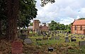 View across St Bartholomew churchyard to Thurstaston Hall.jpg 4,777 × 3,061; 8.6 MB


