Category:Town hall of Chappes (Puy-de-Dôme)
Jump to navigation
Jump to search
| Object location | | View all coordinates using: OpenStreetMap |
|---|
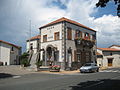
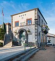
town hall located in Puy-de-Dôme department, France  | |||||
| Upload media | |||||
| Instance of |
| ||||
|---|---|---|---|---|---|
| Location | Chappes, canton of Ennezat | ||||
| Street address |
| ||||
| Has use | |||||
| Owned by | |||||
| Operator | |||||
 | |||||
Media in category "Town hall of Chappes (Puy-de-Dôme)"
The following 7 files are in this category, out of 7 total.
-
 Chappes mairie.jpg 3,072 × 2,304; 2.64 MB
-
 Chappes-FR-63-mairie-a1.jpg 3,024 × 4,032; 5.03 MB
-
 Chappes-FR-63-mairie-a2.jpg 4,032 × 3,024; 4.6 MB
-
 Chappes-FR-63-mairie-a3.jpg 4,032 × 3,024; 4.73 MB
-
 Town hall of Chappes Puy-de-Dome (1).jpg 4,270 × 4,808; 11.72 MB
-
 Town hall of Chappes Puy-de-Dome (2).jpg 3,649 × 5,082; 12.23 MB
-
 Town hall of Chappes Puy-de-Dome (3).jpg 3,861 × 5,595; 13.48 MB


.jpg)
.jpg)
.jpg)