Category:Town hall of Le Pré-Saint-Gervais
Jump to navigation
Jump to search
| Object location | | View all coordinates using: OpenStreetMap |
|---|
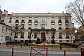
_-_2021-04-28_-_1.jpg) | |||||
| Upload media | |||||
| Instance of | |||||
|---|---|---|---|---|---|
| Location | Le Pré-Saint-Gervais, Seine-Saint-Denis, Île-de-France, Metropolitan France, France | ||||
| Street address |
| ||||
| Located on street |
| ||||
| Owned by | |||||
| Operator | |||||
 | |||||
Media in category "Town hall of Le Pré-Saint-Gervais"
The following 15 files are in this category, out of 15 total.
-
 Hôtel Ville - Le Pré-Saint-Gervais (FR93) - 2021-04-28 - 1.jpg 4,546 × 2,274; 10.4 MB
-
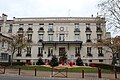
 Hôtel Ville - Le Pré-Saint-Gervais (FR93) - 2021-04-28 - 2.jpg 3,024 × 4,032; 4.3 MB
-
 Hôtel Ville - Le Pré-Saint-Gervais (FR93) - 2021-04-28 - 3.jpg 8,581 × 3,927; 32.76 MB
-
 Le Pré-Saint-Gervais.Grande-Rue.Mairie.jpg 1,197 × 761; 220 KB
-
 Le Pré-Saint-Gervais.Mairie.Semeuse 25 centimes.jpg 1,217 × 763; 221 KB
-
 Mairie Pré St Gervais 1.jpg 5,184 × 3,456; 7.1 MB
-
 Mairie Pré St Gervais 2.jpg 5,184 × 3,456; 5.88 MB
-
 Mairie Pré St Gervais 3.jpg 5,184 × 3,456; 7.64 MB
-
 Mairie Pré St Gervais 4.jpg 5,184 × 3,456; 7.21 MB
-
 Mairie Pré St Gervais 5.jpg 3,456 × 5,184; 6.21 MB
-
 Mairie Pré St Gervais 6.jpg 5,184 × 3,456; 7.32 MB
-
 Mairie Pré St Gervais 7.jpg 5,184 × 3,456; 8.28 MB
-
 Mairie Pré St Gervais 8.jpg 3,456 × 5,184; 5.87 MB
-
 Marie de la ville du Pré-Saint-Gervais 01.jpg 2,034 × 1,187; 1.04 MB
-
 Marmuse 6 - PRE SAINT GERVAIS - La Mairie et la Place.jpg 1,622 × 1,028; 583 KB
_-_2021-04-28_-_2.jpg)
_-_2021-04-28_-_3.jpg)


