Category:Town hall of Saint-Christophe-en-Brionnais
Jump to navigation
Jump to search
| Object location | | View all coordinates using: OpenStreetMap |
|---|
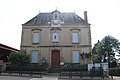
town hall located in Saône-et-Loire department, France  | |||||
| Upload media | |||||
| Instance of |
| ||||
|---|---|---|---|---|---|
| Location | Saint-Christophe-en-Brionnais, canton of Semur-en-Brionnais | ||||
| Street address |
| ||||
| Has use | |||||
| Owned by | |||||
| Operator | |||||
 | |||||
Media in category "Town hall of Saint-Christophe-en-Brionnais"
The following 6 files are in this category, out of 6 total.
-
 Mairie St Christophe Brionnais 1.jpg 5,184 × 3,456; 4.78 MB
-
 Mairie St Christophe Brionnais 2.jpg 5,184 × 3,456; 5.21 MB
-
 Mairie St Christophe Brionnais 3.jpg 5,184 × 3,456; 5.77 MB
-
 Mairie St Christophe Brionnais 4.jpg 5,184 × 3,456; 5.44 MB
-
 Mairie St Christophe Brionnais 5.jpg 5,184 × 3,456; 6.21 MB
-
 Mairie St Christophe Brionnais 6.jpg 5,184 × 3,456; 6.48 MB


