Category:Trebus, Gefallenendenkmal
Jump to navigation
Jump to search
| Object location | | View all coordinates using: OpenStreetMap |
|---|
.jpg) | |||||
| Upload media | |||||
| Instance of | |||||
|---|---|---|---|---|---|
| Location | Hähnichen, Görlitz, Saxony, Germany | ||||
| Street address |
| ||||
| Heritage designation | |||||
| Inception |
| ||||
 | |||||
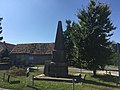
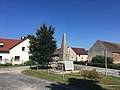
Deutsch: Denkmal mit Gedenksäule für die Gefallenen des Ersten Weltkrieges und einer Gedenktafel für die Gefallenen des Zweiten Weltkrieges in Trebus; von ortschichtlicher Bedeutung; Kulturdenkmal
English: Memorial with obelisk to the fallen soldiers of World War I and plaque to Fallen of World War II in Trebus; locally historical significant; cultural heritage monument
| (Wikidata) |
Media in category "Trebus, Gefallenendenkmal"
The following 6 files are in this category, out of 6 total.
-
 Trebus, Gefallenendenkmal (1).jpg 4,032 × 3,024; 3.97 MB
-
 Trebus, Gefallenendenkmal (2).jpg 4,032 × 3,024; 4.22 MB
-
 Trebus, Gefallenendenkmal (3).jpg 3,024 × 4,032; 2.93 MB
-
 Trebus, Gefallenendenkmal (4).jpg 4,032 × 3,024; 3.65 MB
-
 Trebus, Gefallenendenkmal (5).jpg 4,032 × 3,024; 3.03 MB
-
 Trebus, Gefallenendenkmal (6).jpg 4,032 × 3,024; 3.08 MB
.jpg)
.jpg)
.jpg)
.jpg)
.jpg)