Category:Truman Track
Jump to navigation
Jump to search
walking trail in New Zealand  | |||||
| Upload media | |||||
| Instance of | |||||
|---|---|---|---|---|---|
| Located in protected area | |||||
| Location | Buller District, West Coast Region, New Zealand | ||||
| Operator | |||||
| Maintained by | |||||
| Length |
| ||||
| Terminus | |||||
| Elevation above sea level |
| ||||
 | |||||
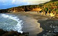
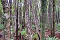
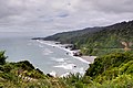
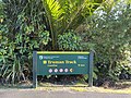
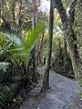
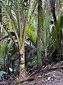
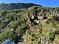
The Truman Track, north of Punakaiki, New Zealand, is a short easy walk (700 m, 15 min). It leads from State Highway 6 to cliffs overlooking the Tasman Sea—although access to the beach is now restricted because of dangerous overhanging rocks. The track, part of Paparoa National Park, passes through mature coastal forest containing nīkau, rātā, and rimu, and emerges into coastal flax and turf vegetation.
Media in category "Truman Track"
The following 82 files are in this category, out of 82 total.
-
 Beach and flax-covered rock stack close to the end of Truman Track near Punakaiki.jpg 4,896 × 3,264; 7.14 MB
-
 Beach near Te Miko (6706331831).jpg 4,000 × 3,000; 2.35 MB
-
 Cabbage trees and flaxes on cliff at the end of Truman Track near Punakaiki.jpg 3,264 × 4,896; 6.79 MB
-
 Flax-covered rock stack off beach at the end of Truman Track near Punakaiki.jpg 4,896 × 3,264; 4.72 MB
-
 Looking south from Truman Track.jpg 5,184 × 3,888; 8.84 MB
-
 Scoured out cliff face at the end of Truman Track near Punakaiki.jpg 4,896 × 3,264; 6.34 MB
-
 Truman Track Flickr A 01.jpg 800 × 599; 114 KB
-
 Truman Track Flickr A 02.jpg 800 × 599; 52 KB
-
 Truman Track Flickr A 03.jpg 4,000 × 3,000; 5.27 MB
-
 Truman Track Flickr A 04.jpg 4,000 × 3,000; 5.28 MB
-
 Truman Track Flickr A 05.jpg 449 × 600; 74 KB
-
 Truman Track Flickr A 06.jpg 4,000 × 3,000; 4.24 MB
-
 Truman Track Flickr A 07.jpg 4,000 × 3,000; 4.66 MB
-
 Truman Track Flickr A 08.jpg 4,000 × 3,000; 4 MB
-
 Truman Track Flickr A 09.jpg 5,298 × 3,258; 12.04 MB
-
 Truman Track Flickr A 10.jpg 5,472 × 3,648; 13 MB
-
 Truman Track Flickr B 01.jpg 4,288 × 2,848; 7.54 MB
-
 Truman Track Flickr B 02.jpg 3,072 × 2,304; 1.63 MB
-
 Truman Track Flickr B 03.jpg 4,496 × 3,000; 5.62 MB
-
 Truman Track Flickr B 04.jpg 4,288 × 2,848; 8 MB
-
 Truman Track Flickr B 05.jpg 2,848 × 4,288; 8.64 MB
-
 Truman Track Flickr B 06.jpg 4,288 × 2,848; 7.12 MB
-
 Truman Track Flickr B 07.jpg 4,288 × 2,848; 7.97 MB
-
 Truman Track Flickr B 09.jpg 4,752 × 3,168; 12.92 MB
-
 Truman Track Flickr B 10.jpg 3,168 × 4,752; 14.83 MB
-
 Truman Track Flickr B 11.jpg 4,288 × 2,848; 8.83 MB
-
 Truman Track Flickr B 12.jpg 4,752 × 3,168; 10.38 MB
-
 Truman Track Flickr B 13.jpg 4,752 × 3,168; 12.77 MB
-
 Truman Track Flickr B 14.jpg 4,752 × 3,168; 10.19 MB
-
 Truman Track Flickr B 15.jpg 4,288 × 2,848; 8.94 MB
-
 Truman Track Flickr B 16.jpg 1,024 × 679; 327 KB
-
 Truman Track MRD 2019 01.jpg 3,024 × 4,032; 2.58 MB
-
 Truman Track MRD 2019 02.jpg 3,024 × 4,032; 3.55 MB
-
 Truman Track MRD 2019 03.jpg 3,024 × 4,032; 5.37 MB
-
 Truman Track MRD 2019 04.jpg 3,024 × 4,032; 2.88 MB
-
 Truman Track MRD 2019 05.jpg 3,024 × 4,032; 2.38 MB
-
 Truman Track MRD 2019 06.jpg 3,024 × 4,032; 4.13 MB
-
 Truman Track MRD 2019 07.jpg 3,024 × 4,032; 4.59 MB
-
 Truman Track MRD 2019 08.jpg 3,024 × 4,032; 4.02 MB
-
 Truman Track MRD 2019 09.jpg 3,024 × 4,032; 2.42 MB
-
 Truman Track MRD 2019 10.jpg 4,032 × 3,024; 4.6 MB
-
 Truman Track MRD 2019 11.jpg 3,024 × 4,032; 4.7 MB
-
 Truman Track MRD 2019 12.jpg 3,024 × 4,032; 3.11 MB
-
 Truman Track MRD 2019 13.jpg 3,024 × 4,032; 2.53 MB
-
 Truman Track MRD 2019 14.jpg 4,000 × 3,000; 2.41 MB
-
 Truman Track MRD 2019 15.jpg 4,032 × 3,024; 2.62 MB
-
 Truman Track MRD 2019 16.jpg 4,032 × 3,024; 2.69 MB
-
 Truman Track MRD 2019 17.jpg 4,000 × 3,000; 2.47 MB
-
 Truman Track MRD 2019 18.jpg 4,000 × 3,000; 2.4 MB
-
 Truman Track MRD 2019 19.jpg 4,000 × 3,000; 2.42 MB
-
 Truman Track MRD 2019 20.jpg 4,032 × 3,024; 3.34 MB
-
 Truman Track MRD 2019 21.jpg 4,032 × 3,024; 3.89 MB
-
 Truman Track MRD 2019 22.jpg 3,024 × 4,032; 2.6 MB
-
 Truman Track MRD 2019 23.jpg 2,721 × 2,472; 861 KB
-
 Truman Track MRD 2022 01.jpg 4,032 × 3,024; 6.82 MB
-
 Truman Track MRD 2022 02.jpg 3,024 × 4,032; 6.89 MB
-
 Truman Track MRD 2022 03.jpg 3,024 × 4,032; 8.01 MB
-
 Truman Track MRD 2022 04.jpg 3,024 × 4,032; 5.67 MB
-
 Truman Track MRD 2022 05.jpg 4,032 × 3,024; 7.37 MB
-
 Truman Track MRD 2022 06.jpg 3,024 × 4,032; 3.5 MB
-
 Truman Track MRD 2022 07.jpg 3,024 × 4,032; 7.04 MB
-
 Truman Track MRD 2022 08.jpg 3,024 × 4,032; 7.44 MB
-
 Truman Track MRD 2022 09.jpg 3,024 × 4,032; 5.29 MB
-
 Truman Track MRD 2022 10.jpg 3,024 × 4,032; 5.55 MB
-
 Truman Track MRD 2022 11.jpg 3,024 × 4,032; 6.92 MB
-
 Truman Track MRD 2022 12.jpg 3,024 × 4,032; 6.08 MB
-
 Truman Track MRD 2022 13.jpg 4,032 × 3,024; 6.3 MB
-
 Truman Track MRD 2022 14.jpg 4,032 × 3,024; 4.97 MB
-
 Truman Track MRD 2022 15.jpg 4,032 × 3,024; 5.81 MB
-
 Truman Track MRD 2022 16.jpg 4,032 × 3,024; 2.16 MB
-
 Truman Track MRD 2022 17.jpg 4,032 × 3,024; 4.18 MB
-
 Truman Track MRD 2022 18.jpg 4,032 × 3,024; 2.83 MB
-
 Truman Track MRD 2022 19.jpg 4,032 × 3,024; 7.66 MB
-
 Truman Track MRD 2022 20.jpg 4,032 × 3,024; 6.12 MB
-
 Truman Track MRD 2022 21.jpg 4,032 × 3,024; 3.17 MB
-
 Truman Track MRD 2022 22.jpg 4,032 × 3,024; 3.69 MB
-
 Truman Track MRD 2022 23.jpg 3,024 × 4,032; 8.25 MB
-
 Truman Track MRD 2022 24.jpg 3,024 × 4,032; 3.61 MB
-
 View from Truman Track back to coastal escarpment.jpg 3,888 × 5,184; 9.38 MB
-
 View south from Truman Track towards Punakaiki.jpg 4,032 × 3,024; 1.48 MB
-
 Viewing platforms at Truman Track MC 01.jpg 5,184 × 3,888; 7.4 MB
-
 Viewing platforms at Truman Track MC 02.jpg 5,184 × 3,888; 9.05 MB

.jpg)


