Category:Tsjerke oan it Dok
Jump to navigation
Jump to search
| Object location | | View all coordinates using: OpenStreetMap |
|---|
church building in Lemsterland, Netherlands  | |||||
| Upload media | |||||
| Instance of | |||||
|---|---|---|---|---|---|
| Dedicated to | |||||
| Location | Lemmer, De Fryske Marren, Friesland, Netherlands | ||||
| Street address |
| ||||
| Located on street |
| ||||
| Heritage designation |
| ||||
| Inception |
| ||||
| official website | |||||
 | |||||
Church:
|
This is a category about rijksmonument number 25749
|
Towerclock:
|
This is a category about a municipal monument in De Fryske Marren with number WN220 |
| Address |
|
Subcategories
This category has only the following subcategory.
O
Media in category "Tsjerke oan it Dok"
The following 34 files are in this category, out of 34 total.
-
 De Lemmer, Tsjerke oan it Dok.jpg 2,252 × 2,191; 1.7 MB
-
 Doopvont (Lemmer).jpg 703 × 1,112; 118 KB
-
 Exterieur OVERZICHT NOORD-OOSTGEVEL - Lemmer - 20269571 - RCE.jpg 1,200 × 953; 353 KB
-
 Exterieur OVERZICHT OOSTGEVEL - Lemmer - 20269572 - RCE.jpg 1,200 × 954; 333 KB
-
 Exterieur OVERZICHT WESTGEVEL (TOREN) - Lemmer - 20269569 - RCE.jpg 951 × 1,200; 248 KB
-
 Exterieur OVERZICHT ZUIDOOST ZIJDE - Lemmer - 20269568 - RCE.jpg 953 × 1,200; 271 KB
-
 Exterieur OVERZICHT ZUIDOOSTGEVEL - Lemmer - 20269570 - RCE.jpg 1,200 × 949; 338 KB
-
 Hervormde kerk Lemmer.jpg 3,648 × 2,736; 701 KB
-
 Holland Lemmer 2004-094.jpg 1,728 × 2,304; 1.11 MB
-
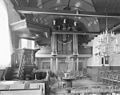
 Interieur, aanzicht orgel, orgelnummer 869 - Lemmer - 20368898 - RCE.jpg 792 × 1,159; 148 KB
-
 INTERIEUR, ORGEL - Lemmer - 20269576 - RCE.jpg 958 × 1,200; 214 KB
-
 INTERIEUR, OVERZICHT NAAR HET OOSTEN - Lemmer - 20269574 - RCE.jpg 1,200 × 965; 231 KB
-
 INTERIEUR, OVERZICHT NAAR HET WESTEN - Lemmer - 20269573 - RCE.jpg 1,200 × 950; 227 KB
-
 INTERIEUR, PREEKSTOEL - Lemmer - 20269575 - RCE.jpg 960 × 1,200; 224 KB
-
 Kerktoren naar het zuid-westen - Lemmer - 20138548 - RCE.jpg 881 × 1,200; 169 KB
-
 Lemmer (13) (8399120219).jpg 2,560 × 1,920; 1.66 MB
-
 Lemmer (36) (8383320126).jpg 2,910 × 2,805; 2.43 MB
-
 Lemmer (37) (8382237411).jpg 2,912 × 4,368; 5.65 MB
-
 Lemmer (38) (8382236061).jpg 2,852 × 3,932; 2.89 MB
-
 Lemmer (39) (8382235341).jpg 2,912 × 4,368; 3.93 MB
-
 Lemmer (41) (8383315344).jpg 4,368 × 2,912; 4.22 MB
-
 Lemmer (42) (8382232095).jpg 2,912 × 4,368; 4.08 MB
-
 Lemmer (43) (8382230981).jpg 4,368 × 2,912; 4.03 MB
-
 Lemmer Church vlakbij de Oude sluis - panoramio.jpg 2,304 × 3,072; 1.29 MB
-
 Lemmer Hervormde kerk.jpg 1,920 × 2,560; 1.46 MB
-
 LEMMER HERVORMDE KERK.jpg 3,456 × 4,608; 2.31 MB
-
 Lemmer imp 128.JPG 3,264 × 2,448; 2.01 MB
-
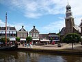
 Lemmer, center.jpg 4,032 × 2,268; 1.64 MB
-
 Lemmer, de Hervormde kerk RM25749 vanaf de Langestreek IMG 2190b 2018-04-17 13.57.jpg 4,191 × 2,592; 6.59 MB
-
 Lemmer, Koartestreek mei Tsjerke oan it Dok.jpg 2,298 × 1,526; 1.5 MB
-
-
 Toren na de restauratie - Lemmer - 20138549 - RCE.jpg 848 × 1,200; 188 KB
-
 Toren na de restauratie - Lemmer - 20138550 - RCE.jpg 853 × 1,200; 216 KB
-
 Toren na de restauratie - Lemmer - 20138551 - RCE.jpg 856 × 1,200; 206 KB

.jpg)


_-_Lemmer_-_20269569_-_RCE.jpg)


_(8399120219).jpg)
_(8383320126).jpg)
_(8382237411).jpg)
_(8382236061).jpg)
_(8382235341).jpg)
_(8383315344).jpg)
_(8382232095).jpg)
_(8382230981).jpg)


