Category:Tumulus de Kerroc'h
Jump to navigation
Jump to search
|
This building is classé au titre des monuments historiques de la France. It is indexed in the base Mérimée, a database of architectural heritage maintained by the French Ministry of Culture, under the reference PA00091603
|
| Object location | | View all coordinates using: OpenStreetMap |
|---|
dolmen in Quéven, France  | |||||
| Upload media | |||||
| Instance of | |||||
|---|---|---|---|---|---|
| Location | Quéven, canton of Pont-Scorff | ||||
| Street address |
| ||||
| Heritage designation |
| ||||
 | |||||
Media in category "Tumulus de Kerroc'h"
The following 2 files are in this category, out of 2 total.
-
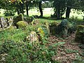 Dolmens du Kerroc’h.jpg 3,264 × 2,448; 2.98 MB
-
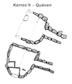 Tumulus de Kerroc’h (plan).png 960 × 1,110; 336 KB
.png)