Category:Tytherington, Gloucestershire
Jump to navigation
Jump to search
village in Tytherington and Itchington, South Gloucestershire, Gloucestershire, UK  | |||||
| Upload media | |||||
| Instance of | |||||
|---|---|---|---|---|---|
| Location | Tytherington and Itchington, South Gloucestershire, Gloucestershire, South West England, England | ||||
 | |||||
Main Wikipedia article: Tytherington, Gloucestershire.
English: Tytherington is a village in South Gloucestershire, England. The quarry to the west belongs to Hanson plc.
Itchington is a hamlet to the south of Tytherington.
Polski: Tytherington – wieś w Anglii, w hrabstwie ceremonialnym Gloucestershire, w dystrykcie (unitary authority) South Gloucestershire. Leży 18 km na północny wschód od miasta Bristol i 163 km na zachód od Londynu.
Subcategories
This category has the following 5 subcategories, out of 5 total.
S
- The Swan, Tytherington (3 F)
T
- Tytherington Quarry (4 F)
- Tytherington railway station (1 F)
- Tytherington War Memorial (4 F)
Media in category "Tytherington, Gloucestershire"
The following 28 files are in this category, out of 28 total.
-
 Approach to Tytherington - geograph.org.uk - 2354177.jpg 640 × 480; 87 KB
-
 Baptist Church, Tytherington - geograph.org.uk - 3402831.jpg 480 × 640; 95 KB
-
 Barn at Brook Farm - geograph.org.uk - 6313079.jpg 2,183 × 719; 549 KB
-

-
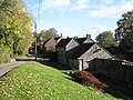 Cottages on the Baden Hill Road, Tytherington - geograph.org.uk - 5183493.jpg 2,592 × 1,944; 2.12 MB
-
 Cottages, Tytherington - geograph.org.uk - 3402836.jpg 640 × 480; 73 KB
-

-
 M5 Motorway near to Tytherington - geograph.org.uk - 6131199.jpg 800 × 533; 489 KB
-
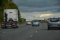
 Northbound M5 near to Itchington - geograph.org.uk - 6131184.jpg 800 × 533; 586 KB
-

-
 Railway crosses the road at Tytherington - geograph.org.uk - 2354180.jpg 640 × 480; 110 KB
-
 Road junctions, Tytherington - geograph.org.uk - 2078803.jpg 640 × 480; 131 KB
-
 Solar Power by the M5 - geograph.org.uk - 6312979.jpg 3,915 × 1,272; 1.99 MB
-
 South Gloucestershire , M5 Motorway - geograph.org.uk - 5951291.jpg 6,000 × 4,000; 6.72 MB
-
 South Gloucestershire , M5 Motorway - geograph.org.uk - 5951292.jpg 6,000 × 4,000; 7.11 MB
-
 South Gloucestershire , M5 Motorway - geograph.org.uk - 5951293.jpg 6,000 × 4,000; 7.49 MB
-
 Southbound M5 near to Tytherington - geograph.org.uk - 6131192.jpg 800 × 533; 522 KB
-
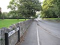
 Stowell Hill Road, Tytherington, 1 - geograph.org.uk - 2078797.jpg 640 × 480; 79 KB
-
 Stowell Hill Road, Tytherington, 2 - geograph.org.uk - 2078809.jpg 640 × 480; 129 KB
-
 The swing - geograph.org.uk - 5904197.jpg 2,048 × 1,536; 1.57 MB
-
 Tytherington , Barmer's Land Farm - geograph.org.uk - 6283843.jpg 6,000 × 4,000; 5.25 MB
-
 Tytherington , Barmer's Lands Farm - geograph.org.uk - 6283846.jpg 6,000 × 4,000; 4.4 MB
-
 Tytherington , M5 Motorway - geograph.org.uk - 6283841.jpg 6,000 × 4,000; 4.48 MB
-
 Tytherington , M5 Motorway - geograph.org.uk - 6283842.jpg 6,000 × 4,000; 4.65 MB
-
 Tytherington MMB 01.jpg 3,657 × 2,507; 4.01 MB
-
 Tytherington Railway Station - geograph.org.uk - 6066965.jpg 1,024 × 710; 156 KB
-
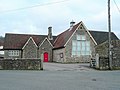 Tytherington village hall - geograph.org.uk - 2246273.jpg 800 × 600; 338 KB
-


