Category:US National Archives series: Central Map File, 1824 - 1960
This series consists of manuscript, annotated, photoprocessed, and published maps pertaining to Indian lands and reservations. Although most of them were prepared by or for the Bureau of Indian Affairs, some were acquired from other sources for official use, often as exhibits or as basic sources of information. Also, some were prepared before the Bureau was established. These maps depict exploration routes, tribal lands, Indian cessions and reservations, areas selected for withdrawal from and additions to reservations, forts and military reservations, boundary lines, private land grants, roads and railroads, railroad grants, allotments to individual Indians, homestead claims, school lands, church lands, townsites, national forests and parks, timber and mineral lands, farming and grazing districts, cultivated and uncultivated lands, irrigable lands, irrigation projects, and rights-of-way through Indian lands of railroads, pipelines, telephone and telegraph lines, highways, electric transmission lines, canals and irrigation ditches. Many of the maps, particularly those showing rights-of-way, are on indefinite loan to the Bureau for use in its land records and title improvement program.
Media in category "US National Archives series: Central Map File, 1824 - 1960"
The following 200 files are in this category, out of 1,733 total.
(previous page) (next page)-
 1941 CCC-ID Telephone School Workers - DPLA - 7e7e2b4a0c371e253b707c511423f14c.jpg 3,594 × 2,148; 4.64 MB
-
 30 years of cooperative wildlife research units 1935-1965. - DPLA - 0aa1174b17abcbd9a53febfe23e55891.pdf 1,275 × 1,650, 43 pages; 3.04 MB
-
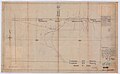
 4 Inch to 8 Inch Gathering Line Plan - NARA - 76028699.jpg 9,759 × 3,744; 6.97 MB
-

-
 6 Inch Crude Oil Pipe Line - NARA - 76028703.jpg 12,160 × 7,808; 9.65 MB
-
 8th Anniversary (Celebration) - DPLA - 0769c58ff27c2341d05b1104811824e2.jpg 1,214 × 814; 66 KB
-
 8th Anniversary (Work Crew) - DPLA - da013ebe0ddd561f584fed06270cedbf.jpg 1,318 × 799; 148 KB
-
 A Diagram of Oregon - DPLA - 19913e6c61aaed26e9821166744e0c85.jpg 15,072 × 12,504; 12.51 MB
-
 A Diagram of Oregon - DPLA - 956e6074c8d9480a108c8f082ed8fd52.jpg 7,758 × 6,113; 10.63 MB
-
 A Diagram of Oregon - DPLA - db27e06085c3e626bcfb04010459f32b.jpg 7,848 × 6,203; 9.87 MB
-
 A Diagram of Oregon - DPLA - e82c0195b08cb18b30bae542f8961bca.jpg 7,761 × 6,050; 10.21 MB
-
-
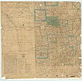
 A New Sectional Map of the State of Missouri - DPLA - 487d70855cff8c62b83aa8f34e423b6e (page 2).jpg 10,704 × 9,569; 18.91 MB
-

-

-
 A Sketch of the Public Surveys in Indiana - DPLA - 52cefbbecfa151574ed06f99e3c7333d.jpg 4,158 × 6,392; 2.47 MB
-
 Acoma Pueblo and Indian Reservation, 1944 - DPLA - 40b505f095aeeb322b802a83098aaeee.jpg 3,695 × 4,766; 1.82 MB
-
 Aerial surveys of waterfowl production in North America, 1955-71. - DPLA - 55d5912f9aefef452899a22a6d72edbe.pdf 1,275 × 1,650, 54 pages; 2.14 MB
-

-
 Amended Map of Puyallup Valley Railway - DPLA - ebcc4808b9cebb88dc5e051f10e81ba3.jpg 20,820 × 8,499; 21.2 MB
-

-
-

-
-

-

-

-

-
 Amended Plat of the Townsite of Dixon - DPLA - d9caf8bef55cd3576d19f7a38955f5c3.jpg 7,220 × 5,728; 3.49 MB
-
 Amos King Home - DPLA - 3a48e7da35bc219c7c8f1db8f5d77c3e.jpg 3,569 × 2,205; 4.16 MB
-
 Amos King Home - DPLA - 73d0e9aed337af6a9be992b94618b534.jpg 3,635 × 2,116; 3.59 MB
-
 Anderson Ranch Barn - DPLA - 57ff8bd219de298e410627746e7942fe.jpg 1,317 × 783; 143 KB
-
 Annotated list of parasites of the bluefish Pomatomus saltatrix. - DPLA - 7ec5bc59dc3a2c762dcbc71593b619a2.pdf 1,275 × 1,650, 18 pages; 473 KB
-

-

-

-
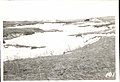
 Area near Polson Townsite - DPLA - 3ef6274b70cda8b17150973e36f444db.jpg 5,472 × 4,548; 3.36 MB
-

-

-
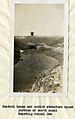
 Asphalt Coated Spillway Culverts - DPLA - 091098ebe7626e989063d1237bee106b.jpg 1,705 × 1,017; 202 KB
-

-
 Avery Scisson's Cattle and Barn - DPLA - 2e2350bb7f5e3c3c71e130b7d9805ff9.jpg 1,039 × 753; 106 KB
-

-
 Barn - DPLA - adbf3a5aec2d208d8b957d4f4aa1cd31.jpg 1,463 × 944; 201 KB
-
 Barn Looking North - DPLA - 1d7822a11e01bee44a29e35cb7e9d315.jpg 1,317 × 790; 132 KB
-
-
 Baseball Team - DPLA - c230c66e39801f7922fef4f33847f4f0.jpg 694 × 1,039; 61 KB
-
 Baseball Team - DPLA - f3400c5b91bcb039c27fcc38e734f007.jpg 729 × 1,041; 47 KB
-
 Battle Creek Bus Road Project 5B - DPLA - 93c208c2820f35d2fee6414955369139.jpg 1,266 × 929; 145 KB
-

-
 Bear Creek Dam (Filling Forms) - DPLA - 25b8af98e99f3f38c3d2fca05fb87528.jpg 857 × 1,373; 111 KB
-

-

-

-
-
-

-

-
 Bigarm-Dayton Road - DPLA - 8e6648a057487f133bc6ad77559c0d2e.jpg 13,264 × 6,560; 8.36 MB
-

-
 Boxing - DPLA - 6230e9497dc03467b1f6a5675f5f4ef9.jpg 717 × 1,017; 62 KB
-
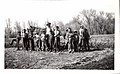
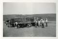
 Boy Holding Young Cattle for Branding - DPLA - 59b338e93aa66d4bb59cde0f01e10e45.jpg 3,344 × 2,426; 1.01 MB
-

-
 Branding - DPLA - 8c689a82c00f9cac6e05118ea6ee2473.jpg 1,039 × 724; 99 KB
-
 Bridge Construction - DPLA - 9f79aa0feba3a371f4ffa6d9792d5654.jpg 1,024 × 710; 85 KB
-
 Bridges - DPLA - 49e4df86209ce25d3a3fc84362a316fa.jpg 1,042 × 739; 53 KB
-
 Bridges - DPLA - 908ec0b462a1bf6a828a64e10541752e.jpg 1,046 × 1,479; 210 KB
-
 Bridges - DPLA - 9a4818bc6b71691a0df16c9837193e69.jpg 1,090 × 1,479; 225 KB
-
 Bridges - DPLA - cfa7f9bb0b2287bbdff4a32d3ca847ef.jpg 1,667 × 964; 145 KB
-
 Brush Dam Built by CCC - DPLA - f15cca276058cdf4db7fb880a924e1ee.jpg 1,998 × 1,420; 509 KB
-
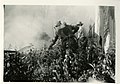 Brush Fire Along Missouri River - DPLA - 47e0f12ebc3b41b0b15bcbf4562265bf.jpg 1,046 × 732; 100 KB
-
 Buffalo (Under Pass) - DPLA - ccafa83581431893c5a2c2860cb162af.jpg 1,330 × 813; 101 KB
-
 Building ("Fair House 360") - DPLA - adccda6032ad1fb90efaaa79a225be2e.jpg 1,536 × 938; 104 KB
-
 Building (Barn and Corral) - DPLA - 5962573c69ca2248f8966903201b6f3b.jpg 1,060 × 760; 67 KB
-

-
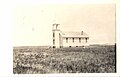 Building (Church) - DPLA - 19222030b8453529dfb159b17c36804e.jpg 1,595 × 1,022; 116 KB
-
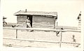
 Building (Coal Shed) - DPLA - 1dd86095952ba4440d9d15742ca7d053.jpg 1,059 × 758; 58 KB
-

-
-
 Building (Housing Development) - DPLA - 7f82d11c80c797d7d854650b15091250.jpg 2,090 × 1,505; 304 KB
-
 Building (Practice Cottage) - DPLA - 502bea6e263e73e1ab42407c5e16fcba.jpg 1,345 × 826; 90 KB
-

-
 Building (The Lenard Home) - DPLA - bb66655a55c79722ec3721c01e076a70.jpg 1,357 × 1,044; 112 KB
-
-
 Building Construction - DPLA - ba66ac548fe3b3923e341e155c3c9c9c.jpg 1,044 × 744; 89 KB
-
 Building No. 117 - DPLA - 1f3faac2a48d9355438bdfe21f596d1d.jpg 1,602 × 871; 167 KB
-
 Building No. 152 - DPLA - bcc9b62f07cac18643d58f42e9b5ddd9.jpg 1,471 × 885; 106 KB
-
 Building Survey - DPLA - d97dd6fc44cb56e103b68d08e703951e.jpg 1,032 × 724; 95 KB
-

-
 Buildings - DPLA - 43e53feb608946aa54ec746a6a6c419f.jpg 1,039 × 677; 359 KB
-
 Buildings - DPLA - ab7aec26e8535b9a389fd80f32215056.jpg 1,059 × 678; 338 KB
-
 Burlap Rug - DPLA - 574dac56943be1598380707b6f386b24.jpg 1,062 × 751; 122 KB
-
 Calf on Range - DPLA - d4d057583db1966d13e6ac399074a56a.jpg 1,024 × 732; 150 KB
-
 Camas Storage - Big Draw Reservoir - DPLA - bd0d243a7da519ea193c407c25c6de8c.jpg 4,512 × 3,166; 1.75 MB
-
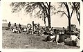
 Campsite - DPLA - fc5fb1d5794594934def11be95cbcb97.jpg 1,042 × 741; 52 KB
-
 Cannonball District - DPLA - dd0f24337c46d74ac7f8d799f2f3e644.jpg 1,032 × 717; 79 KB
-
 Cavalry Riding - DPLA - 65bf02e63ccd20a0d7d36e032a19a17f.jpg 1,241 × 708; 165 KB
-
 CCC Car - DPLA - 9ecf786f60cf4f399f807ac8f6374e82.jpg 1,047 × 677; 356 KB
-

-

-
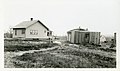
 CCC-ID Personnel Homes - DPLA - d8a29b1f1bc9557ffda444b32d8ede81.jpg 1,332 × 828; 108 KB
-
-
 Cecelia Stafford Home before Repairs - DPLA - 7dcad60772c98d0ab5cdd646493037f2.jpg 3,522 × 2,163; 3.85 MB
-
-
 Champs - DPLA - 1115ad3e8fb1788e3cccadae00109214.jpg 1,317 × 790; 130 KB
-
-
 Chapman House and Log Bunkhouse - DPLA - b1bf17552f5d6329812023bf64a644df.jpg 1,317 × 783; 135 KB
-
 Charles Marshall Farm Corral - DPLA - da653990749f6c9ec26dbcf1a906b917.jpg 1,683 × 988; 161 KB
-
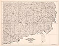
 Chart of Madaline Island Township - NARA - 84786070.jpg 6,464 × 4,894; 1.13 MB
-
 Cheyenne River Indian Reservation, 1944 - DPLA - 3c41f77abbe02ed2d26b15f5a3727039.jpg 7,076 × 5,485; 6.88 MB
-

-

-
 Class Picture - DPLA - b556ddadc53e1c6bb3a9eaf26b8cac2e.jpg 2,082 × 1,499; 313 KB
-
 Class Picture - DPLA - d6b7f7d894415034aea742b815e1d471.jpg 987 × 1,324; 154 KB
-
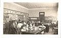 Classroom - DPLA - d00af245592e700bf484bf539a6de04d.jpg 1,336 × 823; 101 KB
-
 Clearing the School Yard - DPLA - 40d03c513d8260d9c23d6a87583536b2.jpg 1,338 × 823; 139 KB
-
 Closeup of Cottage - DPLA - a131e7a05c284a9fcef35569b956eb89.jpg 1,690 × 1,024; 645 KB
-

-
 Colville and Spokane Indian Reservations, 1930 - DPLA - e3081cb10ea4f5927abba3d59b88ca57.jpg 7,650 × 5,109; 5.68 MB
-
 Colville Indian Reservation, 1945 - DPLA - 3fea7263eea88c2f86bc4beffd9f51e2.jpg 12,505 × 9,811; 15.54 MB
-
 Community House Project House Completed - DPLA - 16de40134785388abf19df6829cf9405.jpg 3,520 × 2,130; 3.73 MB
-
 Community Housing Project Construction - DPLA - 7b18ed310f946586f9270a75f4a5952e.jpg 3,582 × 2,151; 3.77 MB
-

-

-
 Comprehensive bibliography of zostera marina. - DPLA - 36e189edcef39e9a882b37ec30dc41c8.pdf 1,275 × 1,650, 39 pages; 970 KB
-

-
 Condemned Building - DPLA - c96b3852e016c228204dabcc2d20de59.jpg 1,039 × 724; 80 KB
-
 Conduit (Pile Driver Tamping) - DPLA - 418c4209e7fad2a479d178a0ac80db9f.jpg 832 × 1,332; 97 KB
-
 Conduit (View of Forms) - DPLA - daacf149c15f407fc92b710c5776bc4b.jpg 1,030 × 761; 88 KB
-
 Conduit and the Trench - DPLA - 37c0cffd375201f17d7b1d3caeb02eb7.jpg 1,026 × 765; 99 KB
-

-

-

-

-
 Construction on Unidentified Home - DPLA - 8f9533e0da6327f71e80a0ea2fa049c0.jpg 1,343 × 800; 163 KB
-
-

-
 Corkin Hill - DPLA - 1144b1a713286fefc684f6ddab30967d.jpg 1,229 × 936; 165 KB
-

-
 Cottage CCC-2 - DPLA - 7701596c915bba810dc0abdbcb0f4e3c.jpg 1,032 × 1,705; 754 KB
-
-

-
-

-

-
 Crow Indian Reservation, 1921 - DPLA - cc66bc50571059e4e30bfe253bc86542.jpg 6,497 × 4,869; 4.13 MB
-
 Crowd - DPLA - 6d71327af6cc54cd94abe02e026620f9.jpg 1,684 × 1,052; 207 KB
-
 Dam 101 (Full Basin) - DPLA - c52a30efd5d87fc95888905f327090dd.jpg 1,056 × 725; 81 KB
-
 Dam 12 (Basin, Fill and Spillway) - DPLA - eeae4da2570e62fb66c0edce20c0d0bf.jpg 1,049 × 777; 102 KB
-
 Dam 120 (Empty Basin) - DPLA - 5c3e30349c205b459936cf61ddf9a87d.jpg 1,058 × 781; 103 KB
-
 Dam 163 (Shallow Basin) - DPLA - 34d27a666932261b30788c6d3feef22d.jpg 1,057 × 767; 105 KB
-
 Dam 197 (Fill and Basin) - DPLA - 994bf4b5d145cd982353121b6c621435.jpg 1,013 × 743; 98 KB
-
 Dam 81 (Basin) - DPLA - bcb29e6e2ee4cb891eb986c6d252c084.jpg 1,047 × 775; 77 KB
-
 Dam Well Located near Trees - DPLA - a124664457123d7dbcd6e49d1b3a2a2a.jpg 1,705 × 1,010; 349 KB
-
 Dam-165 Rolling Waves - DPLA - 7519517459e9df19dc8603fa4e200858.jpg 1,032 × 717; 116 KB
-

-
 Dam-94 Installing Drop Inlet Pipe - DPLA - e6508605220e446433c941eb71e3a7a8.jpg 724 × 1,017; 108 KB
-
 Dan Kuhnhenn - DPLA - 263563cd67b77071c97979939275c8c0.jpg 3,200 × 4,200; 644 KB
-
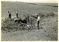
 DeCoteau's Home Site - Men Working - DPLA - 8776fe699a567c5bf46ebb6f7815d837.jpg 3,605 × 2,175; 4.13 MB
-
 Dentist with Patients - DPLA - 014680918021454b09419d1b2c3bb859.jpg 1,053 × 750; 63 KB
-

-
-

-

-

-

-

-

-
-

-

-

-

-

-

-
-

-

-
-

-
-

-
-

-

-
-
-

-

-
-

-

-
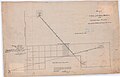
 Diagram of the Pawnee Reservation - DPLA - b18fa54b8f64007609e28cb358260ff4.jpg 7,194 × 6,213; 7.35 MB
-
-

-

-

-
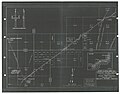
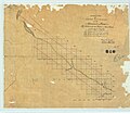
 Diagram of the Sac and Fox Reserve - DPLA - 15305b264ee5846286b222b827e2a179.jpg 6,657 × 6,091; 3.18 MB
-

-
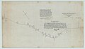
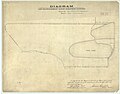
 Diagram of the State of Missouri - DPLA - a62950ad0b6dc7b24df34e6f4a936c40.jpg 7,476 × 6,191; 7.44 MB


_-_DPLA_-_0769c58ff27c2341d05b1104811824e2.jpg)
_-_DPLA_-_da013ebe0ddd561f584fed06270cedbf.jpg)


.jpg)
.jpg)
.jpg)


.jpg)
.jpg)
.jpg)
.jpg)
.jpg)


.jpg)
.jpg)
.jpg)


,_XV_(15),_and_XIV_(14)_East,_Sections_31-36,_Between_Walnut_Creek_and_Honey_Creek_-_DPLA_-_509c7c845adc17b0ab85b522bd91302c.jpg)


_-_DPLA_-_fa1e4f86197a4a2a5a513de746418a9c.jpg)
_-_DPLA_-_25b8af98e99f3f38c3d2fca05fb87528.jpg)


_-_DPLA_-_ccafa83581431893c5a2c2860cb162af.jpg)
_-_DPLA_-_adccda6032ad1fb90efaaa79a225be2e.jpg)
_-_DPLA_-_5962573c69ca2248f8966903201b6f3b.jpg)
_-_DPLA_-_9d8f63887a2fcee6d0949e8901a9e762.jpg)
_-_DPLA_-_19222030b8453529dfb159b17c36804e.jpg)
_-_DPLA_-_1dd86095952ba4440d9d15742ca7d053.jpg)
_-_DPLA_-_ff33dfd327f6cf454d02c599bfd79eb0.jpg)
_-_DPLA_-_e2174aba790c99b73d243f69c137d6df.jpg)
_-_DPLA_-_7f82d11c80c797d7d854650b15091250.jpg)
_-_DPLA_-_502bea6e263e73e1ab42407c5e16fcba.jpg)
_-_DPLA_-_4db8eb6680abeb1659150f7372283ea5.jpg)
_-_DPLA_-_bb66655a55c79722ec3721c01e076a70.jpg)


_-_DPLA_-_5024e2b3cbdc415608a0b86440d502d3.jpg)


_-_DPLA_-_0922a781fdf4ba6f0904ebe102c81d56.jpg)


_-_DPLA_-_418c4209e7fad2a479d178a0ac80db9f.jpg)
_-_DPLA_-_daacf149c15f407fc92b710c5776bc4b.jpg)


.jpg)
.jpg)
.jpg)


_-_DPLA_-_c52a30efd5d87fc95888905f327090dd.jpg)
_-_DPLA_-_eeae4da2570e62fb66c0edce20c0d0bf.jpg)
_-_DPLA_-_34d27a666932261b30788c6d3feef22d.jpg)
_-_DPLA_-_994bf4b5d145cd982353121b6c621435.jpg)
_-_DPLA_-_bcb29e6e2ee4cb891eb986c6d252c084.jpg)


_-_DPLA_-_75ddc97f9b9b3f9e1fb42a0df74007b4.jpg)
.jpg)
.jpg)
.jpg)


_-_DPLA_-_5edbe1153d602c39648bdb505494fac1.jpg)
_-_DPLA_-_4cbe71f09d30a115b01d4e9c6127e80d.jpg)


.jpg)
.jpg)


.jpg)
.jpg)


.jpg)
_-_DPLA_-_5c3e30349c205b459936cf61ddf9a87d.jpg)
.jpg)
.jpg)
.jpg)
.jpg)
.jpg)
.jpg)
.jpg)
.jpg)