Category:US National Archives series: Post and Reservation Maps, 1820 - 1905
Jump to navigation
Jump to search
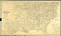
This series consists of manuscript and annotated maps and fortification plans. The majority are large-scale plans drawn during the Civil War of barracks, stables, forts, hospitals, and other buildings used by the Quartermaster Corps. It includes a set of 183 Civil War-era watercolor plans of barracks in the District of Columbia and 84 plans of facilities in Arlington and Alexandria, Virginia. Other items include post plans in the Territory of Michigan, Wisconsin, and Minnesota, and post plans of California dated in the 1870s. A few general maps and miscellaneous plans of railroad terminals also are included.
Media in category "US National Archives series: Post and Reservation Maps, 1820 - 1905"
The following 95 files are in this category, out of 95 total.
-

-

-

-

-

-

-

-

-
 Alexandria Branch Depot for Quarter Master Supplies, Wood Yard, etc. - NARA - 109182988.jpg 5,952 × 7,916; 2.62 MB
-
 Ambulance Stables - NARA - 109183004.jpg 7,882 × 5,920; 4.19 MB
-
 Angel Island, Section of Hospital - DPLA - 72c2c0803eb314cc9dfdf27a79e34f97.jpg 6,604 × 5,508; 4.76 MB
-
 Barracks, Alexandria VA - NARA - 109183002.jpg 19,329 × 14,400; 37.18 MB
-
 Barracks, Kitchens, etc. - NARA - 109182996.jpg 7,897 × 5,984; 2.49 MB
-
 Briggs Barracks - NARA - 109182932.jpg 6,016 × 7,915; 2.75 MB
-
-

-

-
 Church Hospitals - NARA - 109182934.jpg 8,302 × 6,368; 4.2 MB
-
 Cleveland Barracks - NARA - 100307398 (page 1).jpg 3,744 × 10,815; 4.85 MB
-
 Cleveland Barracks - NARA - 100307398 (page 2).jpg 10,788 × 3,748; 5.34 MB
-
 Commissary Mill and Office, Barns, Stables, Sheds, etc. - NARA - 109182936.jpg 7,978 × 6,048; 4.71 MB
-

-

-
-

-
 Convalescent Camp - NARA - 109182938.jpg 8,222 × 6,272; 4.24 MB
-
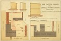
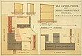
 Cotton Factory Prison - NARA - 109182940.jpg 7,960 × 5,952; 2.74 MB
-
 Drawing of Helmet, Mounted - DPLA - 415602721526c2e0afdd5af12cb21db8.jpg 4,074 × 5,794; 4.01 MB
-
 Drawing of Pillow Sack - DPLA - 11b455de12541ca6ffd5bed7a4b0f67c.jpg 4,116 × 5,836; 3.95 MB
-
 Elevation & Section of a portion of Sickel Hospital - NARA - 109182982.jpg 5,952 × 7,943; 3.37 MB
-

-

-

-
-
 General Plan No. 2 VA. of Slough Branch Hospital - NARA - 109182984.jpg 7,932 × 5,952; 2.87 MB
-
 Government Bakery - NARA - 109183006.jpg 7,600 × 5,280; 2.52 MB
-
 Grace Church General Hospital - NARA - 109182942.jpg 8,034 × 5,792; 2.25 MB
-
 Grosvenor, Branch of Grosvenor and Queen Street Hospitals - NARA - 109182956.jpg 7,881 × 5,952; 2.54 MB
-

-

-

-

-
 King Street Hospital- Offices, Storehouses, etc. - NARA - 109182946.jpg 7,584 × 5,344; 2.12 MB
-
 L'Oveture Hospital, Contraband Barracks, etc. - NARA - 109182952.jpg 6,304 × 8,327; 2.94 MB
-
 Map of Soldiers Rest - NARA - 109182928.jpg 18,247 × 14,400; 12.83 MB
-

-
 Map Showing Contraband Quarters on Mason's Island, Washington, D.C. - NARA - 6050547.jpg 6,624 × 5,127; 1.58 MB
-
 Offices, Barracks, & Stable - DPLA - 92d7f2417ceaf7b528ec6c7c2493463f.jpg 7,891 × 6,080; 2.54 MB
-

-
-

-
-
 Plan for Brick Kitchen - DPLA - e1f6f0f85ddfb2ba5f0dd0916a46dabf.jpg 11,565 × 18,112; 5.6 MB
-
 Plan of Barracks at Camp Copeland, PA - DPLA - 88e624336ce5f1bb80b1971dcc97c0a6 (page 1).jpg 5,544 × 8,355; 1.72 MB
-
 Plan of Barracks at Camp Copeland, PA - DPLA - 88e624336ce5f1bb80b1971dcc97c0a6 (page 2).jpg 8,360 × 5,544; 1.52 MB
-
 Plan of Camp Meigs at Readville, Mass. - DPLA - cee5a42f271012aca609fa2ac551d0ea.jpg 6,052 × 8,671; 2.55 MB
-

-
 Plans for Soldiers Rest, Alexandria VA - DPLA - 4036119d91388cc100bf6af1fa2e6117.jpg 14,337 × 11,712; 24.96 MB
-
 Plans for Soldiers Rest, Alexandria VA - DPLA - 5d7d2e00b7f8f8959834f2e3160c1ee3.jpg 14,400 × 15,349; 19.04 MB
-

-
 Prison, Stable, and Mess House - DPLA - 5f260cadb7d2ee70c823b6d067e0c4b9.jpg 7,853 × 5,696; 2.37 MB
-
 R.Road Wharf & Slaughterhouse - DPLA - 1e35b7769ce7f922813663a461beef54.jpg 7,564 × 5,248; 2.06 MB
-
 Report of Captain James Woodall, Fort Craig, New Mexico, January 22, 1866 - DPLA - 4124bc43b2714cfabd5c65800a2060ed (page 1).pdf 1,539 × 1,252, 2 pages; 2.92 MB
-

-

-
 Report of Colonel R. M. Newport, Baltimore, Maryland, December 26, 1865 - DPLA - 956b5d9d76c7e57f878e16ec4184b434 (page 1).pdf 1,520 × 1,241, 8 pages; 18.02 MB
-

-

-

-

-

-

-

-

-
 Rubber Boots - DPLA - a36a6ad2ecd1859df989d14559871758.jpg 2,601 × 3,924; 1.45 MB
-

-

-

-

-
 Soldiers Rest, Alexandria VA - DPLA - 5ada48fb0f7438bd4cd2a0c246dd9a09.jpg 5,952 × 7,895; 2.88 MB
-
 Soldiers Rest, Alexandria VA - DPLA - eafad98e9424cd872b79998b74418eb2.jpg 18,468 × 14,400; 29.46 MB
-

-
 Timber and Soil Evaluation Map - DPLA - a0e9cceadb4ae853a1899a3e5b466c08 (page 1).jpg 5,034 × 4,233; 3.43 MB
-
 Timber and Soil Evaluation Map - DPLA - a0e9cceadb4ae853a1899a3e5b466c08 (page 2).jpg 5,081 × 4,233; 4.19 MB
-
 U.S. Hospital, Gallipolis, Ohio - DPLA - 322aded68a3a271c3f376a7c2070d239.jpg 9,381 × 7,200; 4.27 MB
-
 U.S. Hospital, Gallipolis, Ohio - DPLA - da2a5debfbe79e64298beb855278e358.jpg 6,031 × 7,424; 5.16 MB
-
 U.S. Hospital, Gallipolis, Ohio - DPLA - fd23417f6fb8e804cf6102114b5f6b73.jpg 6,048 × 7,479; 4.02 MB
-

-
 Wagonmaster Card B12 - DPLA - e5c9011d1f23511c31dacd3f90c139ef.jpg 2,149 × 1,298; 975 KB
-
 Wagonmaster Card H2 - DPLA - 5918b48adaa25e8bd63a24b746a1f453.jpg 2,149 × 1,277; 943 KB
-
 Wagonmaster Card M1 - DPLA - a2084e71f27db4fd9f453b626bde85af.jpg 2,149 × 1,282; 924 KB
-
 Warfs, Hospitals, Storehouses, etc. - DPLA - d6bab8785cbcf0bdb6201b4a302a25de.jpg 7,625 × 5,152; 2.56 MB
-
-
 Wharfs, Offices, and Storehouses - DPLA - ccb41e14dfc8c5f1e8b717cec996d7f1.jpg 7,672 × 5,152; 3.36 MB
-
 Wharfs, Storehouses, etc. - DPLA - 8d12825d3134b9cbdd5192ec5d4ec5e1.JPG 7,629 × 5,088; 2.2 MB
_-_DPLA_-_f21266b95c9950201a7cc503f19043c5_(page_1).jpg)
_-_DPLA_-_f21266b95c9950201a7cc503f19043c5_(page_2).jpg)
_-_DPLA_-_f21266b95c9950201a7cc503f19043c5_(page_3).jpg)
_-_DPLA_-_f21266b95c9950201a7cc503f19043c5_(page_4).jpg)
_-_DPLA_-_f21266b95c9950201a7cc503f19043c5_(page_5).jpg)
_-_DPLA_-_f21266b95c9950201a7cc503f19043c5_(page_6).jpg)
_-_DPLA_-_f21266b95c9950201a7cc503f19043c5_(page_7).jpg)
_-_DPLA_-_f21266b95c9950201a7cc503f19043c5_(page_8).jpg)


,_Washington,_D.C._(Ground_plan_and_views.)_-_NARA_-_305819.jpg)


_Island,_Washington,_D.C._(Ground_plan,_view_and_cross_section_of_one_of_the..._-_NARA_-_305820.jpg)


_-_NARA_-_305822.jpg)


.jpg)
.jpg)


.jpg)
.jpg)
.jpg)
.jpg)
.jpg)
.jpg)
.jpg)
.jpg)
.jpg)
.jpg)


.jpg)
.jpg)


.jpg)
.jpg)