Category:United Kingdom photographs taken on 2008-08-25
Jump to navigation
Jump to search
| ← | Monday 25 August 2008 | → | ||
| ← | August 2008 | → | ||

United Kingdom photographs taken on 25 August 2008.
Image files should be categorized here automatically using {{taken on}} template. Direct categorisation is also possible, if automatic is impossible.
Subcategories
This category has the following 3 subcategories, out of 3 total.
S
Y
Media in category "United Kingdom photographs taken on 2008-08-25"
The following 200 files are in this category, out of 1,052 total.
(previous page) (next page)-
 "For Sale" sign. - geograph.org.uk - 936231.jpg 640 × 480; 96 KB
-

-
 'The Rockies' golf hole - geograph.org.uk - 950704.jpg 640 × 480; 77 KB
-
 5199 at Kingscote station - geograph.org.uk - 1481976.jpg 640 × 480; 78 KB
-
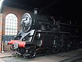 80151 at Sheffield Park engine shed - geograph.org.uk - 1481898.jpg 640 × 480; 66 KB
-

-
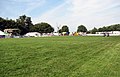
 A day at the Aylsham Show - cattle tent - geograph.org.uk - 937079.jpg 480 × 640; 192 KB
-

-
 A day at the Aylsham Show - cow no. 9-57 - geograph.org.uk - 937089.jpg 446 × 640; 135 KB
-

-
 A day at the Aylsham Show - Jumping Jack - geograph.org.uk - 937034.jpg 358 × 640; 113 KB
-

-

-

-
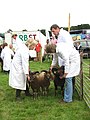
 A day at the Aylsham Show - sheep judging - geograph.org.uk - 937043.jpg 629 × 466; 189 KB
-
 A day at the Aylsham Show - sheep pens - geograph.org.uk - 937057.jpg 480 × 640; 204 KB
-

-

-
 A day at the Aylsham Show - show jumping - geograph.org.uk - 937095.jpg 640 × 361; 110 KB
-
 A day at the Aylsham Show - the Sheepshow - geograph.org.uk - 937106.jpg 480 × 640; 192 KB
-
-
 A day at the Aylsham Show - vintage cars - geograph.org.uk - 937033.jpg 640 × 437; 109 KB
-
-

-

-

-
 A rather weed filled Durlock Stream - geograph.org.uk - 943272.jpg 640 × 480; 200 KB
-
 A working army base - geograph.org.uk - 941892.jpg 640 × 482; 106 KB
-
 A515 looking north - geograph.org.uk - 944538.jpg 640 × 480; 101 KB
-
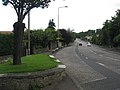 A70 Lanark Road - geograph.org.uk - 936229.jpg 640 × 480; 64 KB
-
 Abbey Wood telephone exchange - geograph.org.uk - 936105.jpg 640 × 480; 84 KB
-
 Above Nant Pasgan - geograph.org.uk - 940126.jpg 640 × 480; 70 KB
-
 Above the shaft - geograph.org.uk - 936050.jpg 640 × 480; 49 KB
-
 Access road at Wall Furlong Farm - geograph.org.uk - 941774.jpg 640 × 480; 78 KB
-
 Access road to Newton Farm - geograph.org.uk - 941763.jpg 640 × 480; 95 KB
-
 Afternoon at Belfast harbour (1) - geograph.org.uk - 936432.jpg 640 × 416; 53 KB
-
 Afternoon at Belfast harbour (2) - geograph.org.uk - 936458.jpg 640 × 444; 82 KB
-
 Afternoon at Belfast harbour (3) - geograph.org.uk - 936543.jpg 640 × 357; 66 KB
-
 Afternoon at Belfast harbour (4) - geograph.org.uk - 936597.jpg 640 × 409; 61 KB
-
 Afternoon at Belfast harbour (5) - geograph.org.uk - 936636.jpg 640 × 358; 66 KB
-
 Afternoon at Belfast harbour (6) - geograph.org.uk - 936677.jpg 640 × 432; 63 KB
-
 Afternoon at Belfast harbour (7) - geograph.org.uk - 936716.jpg 640 × 429; 72 KB
-
 Alfresco eating - geograph.org.uk - 959455.jpg 426 × 640; 77 KB
-
 All Nations Christian Centre - geograph.org.uk - 953364.jpg 640 × 480; 51 KB
-
 All that's left are the posts - geograph.org.uk - 960354.jpg 640 × 426; 77 KB
-
 Allt Doire nan Tota - geograph.org.uk - 963116.jpg 480 × 640; 268 KB
-
 Almshouses behind St Mary's Church - geograph.org.uk - 956388.jpg 480 × 640; 81 KB
-
 Alnwick - geograph.org.uk - 945628.jpg 640 × 426; 79 KB
-
 Another crop - geograph.org.uk - 960546.jpg 640 × 426; 62 KB
-
 Anstruther Harbour and Shore Street - geograph.org.uk - 950717.jpg 640 × 480; 80 KB
-
 Apiary Place - geograph.org.uk - 997858.jpg 640 × 426; 57 KB
-
 Approach to Chester railway station - geograph.org.uk - 937476.jpg 640 × 479; 83 KB
-
 Approaching Pendeford Bridge - geograph.org.uk - 940258.jpg 640 × 480; 76 KB
-
 Arch of the South Transept - geograph.org.uk - 936140.jpg 640 × 498; 125 KB
-
 Arley Church - geograph.org.uk - 1779264.jpg 640 × 480; 70 KB
-
 August 25th 2008 Baconsthorpe Castle (15).JPG 1,920 × 2,560; 1.24 MB
-
 August 25th 2008 Baconsthorpe Castle (5).JPG 2,560 × 1,920; 1.25 MB
-
 August 25th 2008 Baconsthorpe Castle.JPG 2,560 × 1,920; 1.13 MB
-

-

-

-

-
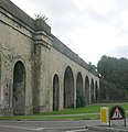
 Avoncliff Aqueduct - geograph.org.uk - 944119.jpg 640 × 468; 276 KB
-
 AXA Insurance Offices, Omagh - geograph.org.uk - 936100.jpg 640 × 480; 55 KB
-
 B4009, Goring Bridge - geograph.org.uk - 945003.jpg 640 × 428; 113 KB
-
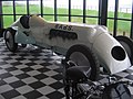 BABS the fasted car in the world Pendine beach - panoramio.jpg 2,048 × 1,536; 611 KB
-
 Back along the footpath - geograph.org.uk - 960573.jpg 640 × 426; 60 KB
-
 Back of Nestles - Bath Road - geograph.org.uk - 944241.jpg 640 × 486; 241 KB
-
 Back of the pavilion - geograph.org.uk - 959480.jpg 640 × 426; 50 KB
-
 Back of the restaurant - geograph.org.uk - 959445.jpg 640 × 426; 58 KB
-
 Bandstand, Bath - geograph.org.uk - 940179.jpg 640 × 480; 135 KB
-
 Bangor Marina (7) - geograph.org.uk - 941364.jpg 640 × 480; 219 KB
-
 Baptist Church - Station Hill - geograph.org.uk - 944215.jpg 510 × 640; 208 KB
-
 Barham mill machinery.JPG 2,304 × 1,728; 681 KB
-
 Barn near Wrickton - geograph.org.uk - 941760.jpg 640 × 480; 65 KB
-
 Barn, Grimwith Moor - geograph.org.uk - 940279.jpg 640 × 427; 217 KB
-
 Barnsole vineyard on Flemming Road - geograph.org.uk - 946677.jpg 640 × 480; 224 KB
-
 Barton Park Packhorse Bridge - geograph.org.uk - 942621.jpg 640 × 519; 301 KB
-
 Basildon - geograph.org.uk - 944785.jpg 640 × 428; 93 KB
-
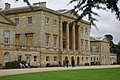
 Basildon Park - geograph.org.uk - 944804.jpg 640 × 428; 127 KB
-
 St Michael's church, Bath - geograph.org.uk - 939550.jpg 480 × 640; 62 KB
-
 Batten Bay - geograph.org.uk - 1169560.jpg 640 × 427; 78 KB
-
 Beach at Seahouses - geograph.org.uk - 946266.jpg 640 × 405; 63 KB
-
 Beadnell Harbour - geograph.org.uk - 946263.jpg 640 × 426; 90 KB
-
 Beadnell Harbour - geograph.org.uk - 946264.jpg 640 × 426; 80 KB
-
 Beehive close - geograph.org.uk - 960768.jpg 640 × 426; 52 KB
-
 Beever Mining Area - geograph.org.uk - 942315.jpg 640 × 427; 221 KB
-
 Beever Reservoir - geograph.org.uk - 938360.jpg 640 × 427; 240 KB
-
 Beever Reservoir - geograph.org.uk - 942319.jpg 427 × 640; 223 KB
-
 Behind the trees - geograph.org.uk - 956844.jpg 640 × 426; 55 KB
-
 Bellfields from the River Wey - geograph.org.uk - 949819.jpg 640 × 427; 185 KB
-
 Birchmere - geograph.org.uk - 936082.jpg 640 × 480; 109 KB
-
 Birdwatching Hide - geograph.org.uk - 941297.jpg 640 × 428; 102 KB
-

-
 Blackberry picking at Crossness - geograph.org.uk - 936096.jpg 640 × 480; 171 KB
-
 Blaen y Glyn Waterfall - geograph.org.uk - 939206.jpg 640 × 480; 125 KB
-
 Blea Beck - geograph.org.uk - 943569.jpg 427 × 640; 219 KB
-
 Blind Junction - geograph.org.uk - 960385.jpg 640 × 426; 57 KB
-
 Blooms Garden Centre - geograph.org.uk - 937104.jpg 640 × 480; 65 KB
-

-
 Blooms Garden Centre, interior 2 - geograph.org.uk - 937097.jpg 640 × 480; 113 KB
-
 Boats on the Wey - geograph.org.uk - 949152.jpg 640 × 427; 191 KB
-
 The Haymaker, Bonby - geograph.org.uk - 936171.jpg 640 × 412; 70 KB
-
 Bond Street - geograph.org.uk - 953386.jpg 640 × 480; 67 KB
-

-
 Boulder, Knots Flat - geograph.org.uk - 940247.jpg 640 × 427; 221 KB
-
 Boundary marker on Sonning bridge - geograph.org.uk - 952213.jpg 480 × 640; 79 KB
-
 Bowers Mill stream - geograph.org.uk - 949233.jpg 427 × 640; 189 KB
-
 Bowling Green, Llwynfedw Gardens - geograph.org.uk - 938215.jpg 504 × 378; 77 KB
-
 Bowness Bay, Bassenthwaite Lake - geograph.org.uk - 960587.jpg 640 × 426; 60 KB
-
 Bramshott Bottom - geograph.org.uk - 946487.jpg 640 × 480; 133 KB
-
 Bramshott Bottom - geograph.org.uk - 946527.jpg 640 × 480; 128 KB
-
 Bramshott Bottom - geograph.org.uk - 946540.jpg 640 × 480; 110 KB
-
 Bramshott Bottom - geograph.org.uk - 946550.jpg 640 × 480; 138 KB
-
 Bramshott Bottom - geograph.org.uk - 946568.jpg 640 × 480; 159 KB
-

-

-
 Brethren's Meeting Room - Cocklebury Road - geograph.org.uk - 944182.jpg 640 × 473; 196 KB
-
 Bridge over Afon Bran - geograph.org.uk - 938154.jpg 640 × 480; 110 KB
-
 Bridge over River Loxley - geograph.org.uk - 958505.jpg 640 × 480; 141 KB
-
 Bridge Road, Colinton - geograph.org.uk - 936239.jpg 640 × 480; 95 KB
-
 Bridges over the Goyt Valley - geograph.org.uk - 960897.jpg 640 × 347; 77 KB
-
 Brighton Road, Purley - geograph.org.uk - 936557.jpg 640 × 480; 64 KB
-
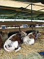 British Longhorn cattle at a show.jpg 480 × 640; 184 KB
-
 Broadford Bridge - geograph.org.uk - 949950.jpg 640 × 427; 188 KB
-
 Brookside - geograph.org.uk - 960763.jpg 640 × 426; 45 KB
-
 Brunel's Railway Viaduct - geograph.org.uk - 944219.jpg 619 × 640; 235 KB
-
-

-
 Building work - geograph.org.uk - 944088.jpg 640 × 480; 98 KB
-
 Bungalows on Larkhill Road - geograph.org.uk - 1457935.jpg 600 × 327; 66 KB
-
 Burghead Bay - geograph.org.uk - 942564.jpg 640 × 485; 100 KB
-
 Burial Brae, Anstruther - geograph.org.uk - 938326.jpg 640 × 426; 105 KB
-
 Bus Station - Timber Street - geograph.org.uk - 944285.jpg 640 × 423; 184 KB
-
 Bus stop on the Street - geograph.org.uk - 958366.jpg 640 × 426; 80 KB
-
 Buttercross - geograph.org.uk - 944299.jpg 640 × 479; 222 KB
-
 Bwlchyrhiw Chapel - geograph.org.uk - 938905.jpg 640 × 480; 73 KB
-
 Calvary Chapel - geograph.org.uk - 953646.jpg 480 × 640; 67 KB
-

-
 Car Dealer, Elmers End - geograph.org.uk - 940623.jpg 640 × 480; 61 KB
-

-

-
 Cartbridge Wharf - geograph.org.uk - 949193.jpg 640 × 427; 203 KB
-
 Cassandra's tearoom, Chawton - geograph.org.uk - 937963.jpg 640 × 480; 60 KB
-
 Cast iron markers - geograph.org.uk - 957276.jpg 640 × 426; 95 KB
-
 Cellardyke from Anstruther - geograph.org.uk - 950723.jpg 640 × 480; 91 KB
-

-

-

-
 Chasing the harvester - geograph.org.uk - 960560.jpg 640 × 426; 52 KB
-
 Chawton Manor - geograph.org.uk - 936449.jpg 640 × 480; 77 KB
-
 Chawton Primary School - geograph.org.uk - 937986.jpg 640 × 480; 72 KB
-

-
 Chippenham Station from Footbridge - geograph.org.uk - 944163.jpg 640 × 429; 188 KB
-
 Chippenham Town Council Offices - geograph.org.uk - 944295.jpg 640 × 488; 233 KB
-

-
 Cholmeley wheatsheaf - geograph.org.uk - 939047.jpg 427 × 640; 110 KB
-
 Cholsey primary school - geograph.org.uk - 960750.jpg 640 × 426; 56 KB
-
 Christleton - bridge 121 - geograph.org.uk - 976297.jpg 640 × 480; 308 KB
-
 Christleton - footpath 20 - geograph.org.uk - 974973.jpg 640 × 480; 284 KB
-
 Christleton - Shropshire Union Canal - geograph.org.uk - 976307.jpg 480 × 640; 333 KB
-
 Church path - Pendomer - geograph.org.uk - 936424.jpg 480 × 640; 93 KB
-
 Church porch at St Nicholas, Chawton - geograph.org.uk - 936489.jpg 451 × 640; 74 KB
-
-
 Church tower - geograph.org.uk - 938323.jpg 426 × 640; 65 KB
-
 Clachaig Water, Kintyre - geograph.org.uk - 936484.jpg 640 × 428; 67 KB
-
 Claverton Buildings, Bath - geograph.org.uk - 940319.jpg 640 × 423; 84 KB
-

-
 Cley Hill - geograph.org.uk - 951832.jpg 640 × 365; 51 KB
-
 Clock Tower at Holyhead rail station - geograph.org.uk - 937458.jpg 640 × 479; 67 KB
-
 Clumps in the distance - geograph.org.uk - 960600.jpg 640 × 426; 62 KB
-
 Cnoc na Sroine from Acharn - geograph.org.uk - 1193804.jpg 640 × 480; 83 KB
-
 Cock Bridge - geograph.org.uk - 936481.jpg 640 × 480; 44 KB
-
 Colinton Parish Church - geograph.org.uk - 936264.jpg 640 × 480; 86 KB
-
 Colinton Village - geograph.org.uk - 936261.jpg 640 × 480; 96 KB
-
 Coming back - geograph.org.uk - 960582.jpg 640 × 426; 61 KB
-

-

-
 Compton Verney House 1.jpg 640 × 428; 68 KB
-
 Condensing Pits, Cupola Smelting Mill - geograph.org.uk - 942943.jpg 427 × 640; 246 KB
-
 Connah's Quay Power Station.jpg 640 × 426; 50 KB
-
 Conwy Castle - geograph.org.uk - 937464.jpg 640 × 479; 66 KB
-
 Cottage off Helen Close - geograph.org.uk - 937132.jpg 427 × 640; 201 KB
-
 Cottage on Broad Street, Wokingham - geograph.org.uk - 944685.jpg 428 × 640; 67 KB
-
 Courtyard at the Talbot Inn - geograph.org.uk - 940595.jpg 640 × 480; 113 KB
-
 Crescent Street - geograph.org.uk - 937204.jpg 640 × 480; 82 KB
-
 Crop near Mill Brook - geograph.org.uk - 960539.jpg 640 × 426; 61 KB
-
 Crops towards Hithercroft - geograph.org.uk - 960578.jpg 640 × 426; 49 KB
-
 Cross in the corner - geograph.org.uk - 958287.jpg 640 × 426; 63 KB
-
 Cross Keys PH, Rochdale Road - geograph.org.uk - 937142.jpg 640 × 480; 80 KB
-
 Crossroads - geograph.org.uk - 972520.jpg 640 × 418; 86 KB
-
 Crossroads - geograph.org.uk - 972521.jpg 640 × 426; 68 KB
-

-
 Cunzie Street, Anstruther - geograph.org.uk - 938327.jpg 640 × 439; 93 KB
-
 Cupola Smelt Mill - geograph.org.uk - 943013.jpg 640 × 427; 353 KB
-
 Curdworth Bottom Lock - geograph.org.uk - 1232018.jpg 640 × 429; 73 KB
-
 Curious Sheep - geograph.org.uk - 944478.jpg 640 × 427; 182 KB
-
 Curved arches - geograph.org.uk - 944552.jpg 640 × 480; 68 KB
-
 Cut field on the hill - geograph.org.uk - 960498.jpg 640 × 426; 44 KB
-
 Cutting a swathe - geograph.org.uk - 960553.jpg 640 × 426; 57 KB


_-_geograph.org.uk_-_936432.jpg)
_-_geograph.org.uk_-_936458.jpg)
_-_geograph.org.uk_-_936543.jpg)
_-_geograph.org.uk_-_936597.jpg)
_-_geograph.org.uk_-_936636.jpg)
_-_geograph.org.uk_-_936677.jpg)
_-_geograph.org.uk_-_936716.jpg)


.JPG)
.JPG)

_-_geograph.org.uk_-_936736.jpg)
_-_geograph.org.uk_-_936746.jpg)
_-_geograph.org.uk_-_936755.jpg)
_-_geograph.org.uk_-_936768.jpg)


_-_geograph.org.uk_-_941364.jpg)


_-_geograph.org.uk_-_952257.jpg)


