Category:Unteres Tor (Neuburg an der Donau)
Jump to navigation
Jump to search
| Object location | | View all coordinates using: OpenStreetMap |
|---|
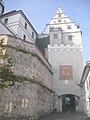
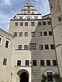
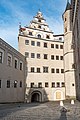
This is the category of the Bavarian Baudenkmal (cultural heritage monument) with the ID D-1-85-149-47 (Wikidata)
|
Deutsch: Toranlage, sogenanntes Unteres Tor, spätmittelalterlich, mit Zinnenkranz und Wappen des Kurfürsten Karl Theodor, im 17. Jahrhundert überbaut, 1752 wohl erneuert
Residenzstraße A 2, Neuburg an der Donau, Bayern, Deutschland
Residenzstraße A 2, Neuburg an der Donau, Bayern, Deutschland
Media in category "Unteres Tor (Neuburg an der Donau)"
The following 11 files are in this category, out of 11 total.
-
 D-ND-Neuburg3.JPG 768 × 1,024; 215 KB
-
 GER Neuburg an der Donau, Amalienstraße 002.jpg 3,930 × 2,947; 2.25 MB
-
 GER Neuburg an der Donau, Elisenbrücke 008.jpg 3,930 × 2,947; 2.13 MB
-
 GER Neuburg an der Donau, Schloss Neuburg 001.jpg 3,024 × 4,032; 3.42 MB
-
 GER Neuburg an der Donau, Schloss Neuburg 002.jpg 3,024 × 4,032; 3.17 MB
-
 GER Neuburg an der Donau, Schloss Neuburg 023.jpg 3,024 × 4,032; 2.55 MB
-
 Neuburg - Unteres Tor und Schloss 30.06.2022.jpg 3,971 × 2,963; 4.74 MB
-
 Neuburg an der Donau Schloss 065.jpg 3,042 × 4,563; 10.12 MB
-
 Neuburg an der Donau, Residenzstraße A 2, Schloß, Nordtrakt 20170830 001.jpg 4,016 × 6,016; 10.83 MB
-
 Neuburg an der Donau, Residenzstraße A 2, Schloß, Nordtrakt 20170830 002.jpg 3,955 × 5,924; 14.45 MB
-
 Unteres Tor (Residenztor).JPG 2,304 × 3,072; 3.31 MB


.JPG)