Category:Unterferdinandsdorf
Jump to navigation
Jump to search
| Object location | | View all coordinates using: OpenStreetMap |
|---|
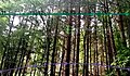
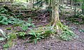
Deutsch: Unterferdinandsdorf war ein Weiler am Nordhang des Winterhauchs bei Waldbrunn. Von dem um 1850 aufgegebenen Weiler existieren noch zahlreiche Mauerreste, die zum Landschaftsschutzgebiet „Reisenbachtal“ zählen. Unterferdinandsdorf bildete zusammen mit Oberferdinandsdorf die Gemeinde Ferdinandsdorf
English: Unterferdinandsdorf was a hamlet on the northern slope of Winterhauchs at Waldbrunn, in Germany. From the abandoned around 1850 hamlet, there are still numerous remains of the wall, which belong to the landscape protection area "Reisenbachtal". Unterferdinandsdorf formed together with Oberferdinandsdorf the municipality Ferdinandsdorf.
hamlet which was abandoned in 1850   | |||||
| Upload media | |||||
| Instance of |
| ||||
|---|---|---|---|---|---|
| Part of | |||||
| Location |
| ||||
| Located in or next to body of water | |||||
 | |||||
Media in category "Unterferdinandsdorf"
The following 75 files are in this category, out of 75 total.
-
 Gebäudereste Unterferdinandsdorfs 2.jpg 4,608 × 3,456; 6.76 MB
-
 Gebäudereste Unterferdinandsdorfs 3.jpg 4,608 × 3,456; 7.14 MB
-
 Gebäudereste Unterferdinandsdorfs 4.jpg 3,456 × 4,608; 6.84 MB
-
 Gebäudereste Unterferdinandsdorfs 5.jpg 4,608 × 3,456; 7.61 MB
-
 Gebäudereste Unterferdinandsdorfs 6.jpg 4,608 × 3,456; 7.25 MB
-
 Gebäudereste Unterferdinandsdorfs.jpg 4,608 × 3,456; 6.86 MB
-
 Gesicherter Tiefbrunnen bei Unterferdinandsdorf - Messung.jpg 3,072 × 1,728; 2.67 MB
-
 Gesicherter Tiefbrunnen bei Unterferdinandsdorf Blick hinein.jpg 4,608 × 3,456; 5.39 MB
-

-
 Gesicherter Tiefbrunnen bei Unterferdinandsdorf Blick in den Brunnen.jpg 3,072 × 1,728; 1.76 MB
-
 Gesicherter Tiefbrunnen bei Unterferdinandsdorf.jpg 4,608 × 3,456; 7.33 MB
-
 Infotafel Unterferdinandsdorf im Reisenbacher Grund.jpg 3,840 × 2,160; 3.9 MB
-
 Lage von Ober- und Unterferdinandsdorf.jpg 1,487 × 793; 561 KB
-

-
 Ruine im ehemaligen Unterferdinandsdorf.jpg 4,608 × 3,456; 7.1 MB
-
 Ruine im ehemaligen Unterferdinandsdorf1.jpg 4,608 × 3,456; 7.57 MB
-
 Ruine im ehemaligen Unterferdinandsdorf2.jpg 4,608 × 3,456; 7.92 MB
-
 Ruine im ehemaligen Unterferdinandsdorf3.jpg 4,608 × 3,456; 7.1 MB
-
 Ruine im ehemaligen Unterferdinandsdorf4.jpg 4,608 × 3,456; 7.38 MB
-
 Ruine Unterferdinandsdorfs, Gewölbekeller.jpg 4,608 × 2,764; 3.08 MB
-
 Siedlungsreste Unterferdinandsdorf 2.jpg 4,608 × 3,268; 4.76 MB
-
 Siedlungsreste Unterferdinandsdorf 3.jpg 3,897 × 2,764; 2.29 MB
-
 Siedlungsreste Unterferdinandsdorf 4.jpg 3,903 × 2,765; 3.31 MB
-
 Siedlungsreste Unterferdinandsdorf.jpg 2,967 × 2,103; 1.98 MB
-
 Siedlungsreste Unterferdinandsdorfs 2.jpg 3,588 × 2,152; 2.25 MB
-
 Siedlungsreste Unterferdinandsdorfs 3.jpg 4,608 × 2,765; 3.32 MB
-
 Siedlungsreste Unterferdinandsdorfs 4.jpg 4,608 × 2,765; 3.86 MB
-
 Siedlungsreste Unterferdinandsdorfs 5.jpg 4,608 × 2,765; 3.79 MB
-
 Siedlungsreste Unterferdinandsdorfs.jpg 4,608 × 2,765; 4.74 MB
-
 Siedlungsspuren Unterferdinandsdorf 2.jpg 4,608 × 3,456; 6.43 MB
-
 Siedlungsspuren Unterferdinandsdorf 3.jpg 4,608 × 3,456; 7.25 MB
-
 Siedlungsspuren Unterferdinandsdorf 4.jpg 4,608 × 3,456; 8.1 MB
-
 Siedlungsspuren Unterferdinandsdorf 5.jpg 4,608 × 3,456; 6.49 MB
-
 Siedlungsspuren Unterferdinandsdorf.jpg 4,608 × 3,456; 7.03 MB
-
 Treppenstufen und Grundmauer.jpg 4,608 × 3,456; 6.38 MB
-
 Unterdinandsdorf, Steinhaufen oberhalb des bebauten Bereichs.jpg 3,072 × 1,728; 3.75 MB
-
 Unterferdinandsdof Weg Richtung Oberferdinandsdorf.jpg 4,608 × 2,765; 4.28 MB
-
 Unterferdinandsdorf - Sonnenlauf 1.jpg 1,508 × 883; 384 KB
-
 Unterferdinandsdorf - Sonnenlauf 2.png 1,080 × 1,506; 1.28 MB
-
 Unterferdinandsdorf Details Keller.jpg 3,072 × 1,728; 2.06 MB
-
 Unterferdinandsdorf Gebäudereste 2.jpg 4,608 × 3,456; 6.64 MB
-
 Unterferdinandsdorf Gebäudereste 3.jpg 4,608 × 3,456; 6 MB
-
 Unterferdinandsdorf Gebäudereste 4.jpg 4,608 × 3,456; 5.84 MB
-
 Unterferdinandsdorf Gebäudereste 5.jpg 4,608 × 3,456; 6.39 MB
-
 Unterferdinandsdorf Gebäudereste.jpg 4,608 × 3,456; 6.37 MB
-
 Unterferdinandsdorf Kellergrube.jpg 4,608 × 3,456; 6.64 MB
-
 Unterferdinandsdorf Mauer bei Wasserquelle.jpg 4,608 × 3,456; 6.19 MB
-
 Unterferdinandsdorf Siedlungsreste 2.jpg 4,608 × 2,765; 4.37 MB
-
 Unterferdinandsdorf Siedlungsreste 3.jpg 4,608 × 2,765; 3.49 MB
-
 Unterferdinandsdorf Siedlungsreste 4.jpg 4,608 × 2,765; 3.14 MB
-
 Unterferdinandsdorf Siedlungsreste.jpg 4,608 × 2,765; 2.52 MB
-
 Unterferdinandsdorf Siedlungsspuren 2.jpg 4,608 × 3,456; 8.22 MB
-
 Unterferdinandsdorf Siedlungsspuren 3.jpg 4,608 × 3,456; 5.29 MB
-
 Unterferdinandsdorf Siedlungsspuren 4.jpg 4,608 × 3,456; 6.47 MB
-
 Unterferdinandsdorf Siedlungsspuren 5.jpg 4,608 × 3,456; 5.69 MB
-
 Unterferdinandsdorf Siedlungsspuren.jpg 4,608 × 3,456; 3.79 MB
-
 Unterferdinandsdorf Zivilisationsreste 2.jpg 3,456 × 4,608; 5.47 MB
-
 Unterferdinandsdorf Zivilisationsreste 3.jpg 4,608 × 3,456; 7.58 MB
-
 Unterferdinandsdorf Zivilisationsreste.jpg 4,608 × 3,456; 6.39 MB
-
 Unterferdinandsdorf, Häusserrest 1.jpg 1,728 × 3,072; 3.47 MB
-
 Unterferdinandsdorf, Häusserrest 2.jpg 3,072 × 1,728; 3.53 MB
-
 Unterferdinandsdorf, Häusserrest 3.jpg 3,072 × 1,728; 3.72 MB
-
 Unterferdinandsdorfer Siedlungspuren 01.jpg 3,072 × 1,728; 3.5 MB
-
 Unterferdinandsdorfer Siedlungspuren 02.jpg 3,072 × 1,728; 3.72 MB
-
 Unterferdinandsdorfer Siedlungspuren 03.jpg 3,072 × 1,728; 3.77 MB
-
 Unterferdinandsdorfer Siedlungspuren 04.jpg 3,072 × 1,728; 3.87 MB
-
 Unterferdinandsdorfer Siedlungspuren 05.jpg 3,072 × 1,728; 3.59 MB
-
 Unterferdinandsdorfer Siedlungspuren 06.jpg 3,072 × 1,728; 2.36 MB
-
 Unterferdinandsdorfer Siedlungspuren 07.jpg 3,072 × 1,728; 3.47 MB
-
 Unterferdinandsdorfer Siedlungspuren 08.jpg 3,072 × 1,728; 3.49 MB
-
 Waldbrunn - Winterhauch - Unterferdinandsdorf - Ruine eines Hauses.jpg 6,000 × 4,000; 28.61 MB
-
 Wegweiser Unterferdinandsdorf.jpg 1,728 × 3,072; 3.45 MB
-
 Zivilisationsspuren Unterferdinandsdorf 2.jpg 4,608 × 3,456; 7 MB
-
 Zivilisationsspuren Unterferdinandsdorf 3.jpg 4,608 × 3,456; 6.69 MB
-
 Zivilisationsspuren Unterferdinandsdorf.jpg 4,608 × 3,456; 7.06 MB


.jpg)


