Category:Unterroth
Jump to navigation
Jump to search
municipality of Germany    | |||||
| Upload media | |||||
| Instance of |
| ||||
|---|---|---|---|---|---|
| Part of |
| ||||
| Location | Neu-Ulm, Swabia, Bavaria, Germany | ||||
| Head of government |
| ||||
| Population |
| ||||
| Area |
| ||||
| Elevation above sea level |
| ||||
| official website | |||||
 | |||||
Subcategories
This category has the following 3 subcategories, out of 3 total.
B
M
Media in category "Unterroth"
The following 9 files are in this category, out of 9 total.
-
 Altar in der Pfarrkirche in Unterroth.jpg 6,000 × 4,000; 3.43 MB
-
 Aussegnungshalle in Unterroth.jpg 6,000 × 4,000; 4.22 MB
-
 Gemeindehaus in Unterroth.jpg 6,000 × 4,000; 4.39 MB
-
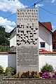 Kriegerdenkmal in Unterroth.jpg 4,000 × 6,000; 6.96 MB
-
 Orgel in der Pfarrkirche in Unterroth.jpg 5,847 × 3,899; 2.9 MB
-
 Unterroth im Landkreis Neu-Ulm.png 493 × 722; 52 KB
-
 Unterroth in NU.svg 527 × 553; 491 KB
-
 Wappen Unterroth.svg 481 × 516; 43 KB
-
 Wappen von Unterroth.png 180 × 202; 73 KB


