Category:Unterste Gasse 14 (Iversheim)
Jump to navigation
Jump to search
| Object location | | View all coordinates using: OpenStreetMap |
|---|
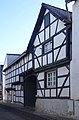
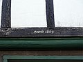
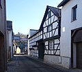
| This category shows a heritage building in Germany, located in the North Rhine-Westphalian city Bad Münstereifel (no. 63). |
Media in category "Unterste Gasse 14 (Iversheim)"
The following 5 files are in this category, out of 5 total.
-
 Iversheim Unterste Gasse 14 (01).jpg 3,304 × 5,024; 2.5 MB
-
 Iversheim Unterste Gasse 14 (02).jpg 3,872 × 4,896; 3.59 MB
-
 Iversheim Unterste Gasse 14 (03).jpg 5,184 × 3,888; 3.83 MB
-
 Iversheim Unterste Gasse 14 (04).jpg 5,184 × 3,888; 3.91 MB
-
 Iversheim Unterste Gasse 14 (05).jpg 4,050 × 3,564; 2.24 MB
.jpg)
.jpg)
.jpg)
.jpg)
.jpg)