Category:Untertorturm (Bad Camberg)
Jump to navigation
Jump to search
| Object location | | View all coordinates using: OpenStreetMap |
|---|
Cultural heritage monument in Bad Camberg, Hesse, Germany  | |||||
| Upload media | |||||
| Instance of | |||||
|---|---|---|---|---|---|
| Part of | |||||
| Location | Bad Camberg, Limburg-Weilburg, Giessen Government Region, Hesse, Germany | ||||
| Street address |
| ||||
| Heritage designation | |||||
 | |||||
This is the category of the Hessian Kulturdenkmal (cultural monument) with the ID 68993 (Wikidata)
|
Media in category "Untertorturm (Bad Camberg)"
The following 3 files are in this category, out of 3 total.
-
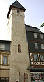
 Bad Camberg - Unterturm.jpg 1,500 × 2,000; 304 KB
-
 Camberg untertor.jpg 1,107 × 2,046; 1.13 MB
-
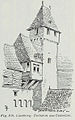 Luthmer III-108-Camberg Torturm am Untertor.jpg 738 × 1,178; 573 KB

