Category:Upper Greensand
Jump to navigation
Jump to search
Subcategories
This category has the following 15 subcategories, out of 15 total.
+
- Upper Greensand - maps (5 F)
- Upper Greensand - stratigraphy (12 F)
.
B
- Bulbarrow Hill (10 F)
F
H
- Hooken Landslide (31 F)
T
- The Chink (Isle of Wight) (3 F)
U
Media in category "Upper Greensand"
The following 19 files are in this category, out of 19 total.
-
 At the end of Court Lane, Bratton - geograph.org.uk - 1726367.jpg 640 × 494; 95 KB
-
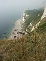
 Beacon Hill - geograph.org.uk - 181715.jpg 640 × 480; 72 KB
-
 Beer, View towards Seaton Hole - geograph.org.uk - 1736972.jpg 800 × 535; 414 KB
-
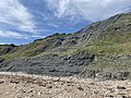 Black Ven.jpg 4,032 × 3,024; 5.42 MB
-
-
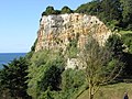
 Cliffs above Hooken landslip - geograph.org.uk - 242208.jpg 640 × 480; 107 KB
-
 Compton Bay - geograph.org.uk - 1380387.jpg 640 × 426; 175 KB
-

-
 Edge of Sidford from Core Hill - geograph.org.uk - 747348.jpg 640 × 480; 76 KB
-
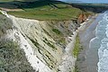
 Erosion above Compton Bay - geograph.org.uk - 1378875.jpg 640 × 427; 169 KB
-
 Head Ledge - geograph.org.uk - 906027.jpg 458 × 640; 95 KB
-
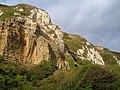
 Hooken Landslide from Beer Head - geograph.org.uk - 231498.jpg 480 × 640; 306 KB
-
 North-west of Shippards Chine - geograph.org.uk - 1378795.jpg 640 × 427; 190 KB
-

-
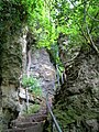 The Chink, Isle of Wight, ascending.jpg 768 × 1,024; 487 KB
-
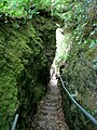 The Chink, Isle of Wight, descending.jpg 768 × 1,024; 520 KB
-
 Undercliff steephill 2012.jpg 480 × 640; 280 KB
-

-
 Exposed geology - geograph.org.uk - 484449.jpg 640 × 477; 142 KB


