Category:Upper Witham IDB
Jump to navigation
Jump to search
UK local land-drainage authority | |||||
| Upload media | |||||
| Instance of | |||||
|---|---|---|---|---|---|
| Location |
| ||||
 | |||||
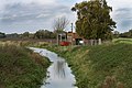
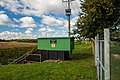
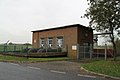
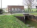
The Upper Witham Internal Drainage Board (IDB) is a land drainage authority responsible for the management of low lying land to the west of Lincoln, England. Their area coverts the course of the upper River Witham, the River Till, and part of the Fossdyke Navigation.
Media in category "Upper Witham IDB"
The following 6 files are in this category, out of 6 total.
-
 Burton Pumping station (geograph 3728055).jpg 1,536 × 1,024; 1.75 MB
-
 Decoy Pumping Station, Swanpool, Lincoln (geograph 6634688).jpg 1,600 × 1,067; 512 KB
-
 Oxpasture Pumping Station (geograph 3735029).jpg 2,256 × 1,504; 1.76 MB
-
 Oxpasture pumping station - geograph.org.uk - 787215.jpg 640 × 427; 70 KB
-
 Oxpasture pumping station downstream.jpg 4,608 × 3,456; 5.39 MB
-
 Till Catchwater at Pyewipe.jpg 4,608 × 3,456; 4.61 MB
.jpg)
.jpg)
.jpg)


