Category:Upplands runinskrifter 914
Jump to navigation
Jump to search
| Object location | | View all coordinates using: OpenStreetMap |
|---|
 | |||||
| Upload media | |||||
| Instance of |
| ||||
|---|---|---|---|---|---|
| Location | Börje, Ulleråker Hundred, Uppland, Svealand, Sweden | ||||
| Heritage designation |
| ||||
 | |||||
|
This is a category about an archaeological site or a monument in Sweden, number 10021300670001 in the RAÄ Fornsök database. |
Media in category "Upplands runinskrifter 914"
The following 9 files are in this category, out of 9 total.
-
 U914 Ströja - KMB - 16000300026364.jpg 512 × 768; 211 KB
-
 U914 Ströja - KMB - 16000300026366.jpg 2,048 × 3,072; 1.18 MB
-
 U914 Ströja - KMB - 16000300026367.jpg 512 × 768; 195 KB
-
 U914 Ströja - KMB - 16000300026368.jpg 512 × 768; 214 KB
-
 U914 Ströja - KMB - 16000300026369.jpg 512 × 768; 211 KB
-
 U914 Ströja - KMB - 16000300026370.jpg 512 × 768; 206 KB
-
 U914 Ströja - KMB - 16000300026371.jpg 512 × 768; 224 KB
-
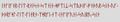 Upplands runinskrifter 914 runes.png 442 × 80; 5 KB
-
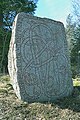
 Upplands runinskrifter 914.JPG 750 × 1,000; 408 KB


