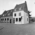
Category:Valkenstraat 22, Vianen
Jump to navigation
Jump to search
| Object location | | View all coordinates using: OpenStreetMap |
|---|
 | |||||
| Upload media | |||||
| Instance of |
| ||||
|---|---|---|---|---|---|
| Location | Vianen, Vijfheerenlanden, Utrecht, Netherlands | ||||
| Street address |
| ||||
| Heritage designation |
| ||||
 | |||||
|
This is a category about rijksmonument number 37318
|
| Address |
|
Media in category "Valkenstraat 22, Vianen"
The following 4 files are in this category, out of 4 total.
-
 Gevels voor - Vianen - 20242122 - RCE.jpg 1,200 × 808; 178 KB
-
 Vianen - Valkenstraat 22 - Rijksmonument 37318.JPG 2,592 × 3,872; 4.02 MB
-
 Voorgevels - Vianen - 20242119 - RCE.jpg 1,197 × 1,200; 340 KB
-
 Voorgevels - Vianen - 20242120 - RCE.jpg 1,181 × 1,200; 271 KB


