Category:Verwersstraat 11, 's-Hertogenbosch
Jump to navigation
Jump to search
| Object location | | View all coordinates using: OpenStreetMap |
|---|
house in 's-Hertogenbosch, Netherlands  | |||||
| Upload media | |||||
| Instance of | |||||
|---|---|---|---|---|---|
| Location | 's-Hertogenbosch, North Brabant, Netherlands | ||||
| Street address |
| ||||
| Heritage designation |
| ||||
 | |||||
|
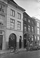
This is a category about rijksmonument number 21887
|
| Address |
|
Media in category "Verwersstraat 11, 's-Hertogenbosch"
The following 7 files are in this category, out of 7 total.
-
 's-Hertogenbosch Rijksmonument 21887 Verwersstraat 11.JPG 2,736 × 3,648; 3.2 MB
-
 's-Hertogenbosch Rijksmonument 21889 Verwersstraat 15A-D.JPG 3,648 × 2,500; 835 KB
-
 Overzicht - 's-Hertogenbosch - 20110934 - RCE.jpg 824 × 1,200; 215 KB
-
 Overzicht van de voorgevels - 's-Hertogenbosch - 20381424 - RCE.jpg 1,200 × 1,188; 257 KB
-
 Overzicht van de voorgevels - 's-Hertogenbosch - 20381428 - RCE.jpg 1,191 × 1,200; 270 KB
-
 Voorgevels - 's-Hertogenbosch - 20110932 - RCE.jpg 829 × 1,200; 199 KB
-
 Voorgevels - 's-Hertogenbosch - 20110933 - RCE.jpg 788 × 1,200; 211 KB


