Category:Vetkamp 28, Nijkerk
Jump to navigation
Jump to search
| Object location | | View all coordinates using: OpenStreetMap |
|---|
 | |||||
| Upload media | |||||
| Instance of | |||||
|---|---|---|---|---|---|
| Location | Nijkerk, Gelderland, Netherlands | ||||
| Street address |
| ||||
| Located on street |
| ||||
| Heritage designation |
| ||||
| Date of official opening |
| ||||
| Date of official closure |
| ||||
 | |||||
|
This is a category about rijksmonument number 31022
|
| Address |
|
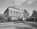
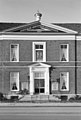
Media in category "Vetkamp 28, Nijkerk"
The following 11 files are in this category, out of 11 total.
-
 Aanzicht - Nijkerk - 20166691 - RCE.jpg 1,200 × 801; 206 KB
-
 Dorpsgezicht, reproductie van prentbriefkaart - Nijkerk - 20166707 - RCE.jpg 1,200 × 976; 245 KB
-
 Exterieur VOORGEVEL, INGANGSPARTIJ - Nijkerk - 20339662 - RCE.jpg 951 × 1,200; 366 KB
-
 Nijkerk - Vetkamp 28 - Rijksmonument 31021.jpg 1,600 × 1,200; 499 KB
-
 Nijkerk - Vetkamp 28 - rijksmonument 31022.jpg 1,600 × 1,200; 957 KB
-
 Old children refugees building at Nijkerk - panoramio.jpg 4,288 × 2,848; 3.46 MB
-
 Overzicht voorgevel en linker zijgevel - Nijkerk - 20359722 - RCE.jpg 1,200 × 956; 255 KB
-
 Particulier Gereformeerd Burgerweeshuis Nijkerk schilderij.JPG 2,561 × 3,294; 2.05 MB
-
 Particulier Gereformeerd Burgerweeshuis Nijkerk.JPG 3,824 × 2,596; 2.27 MB
-
 Partikulier grifformeard Boargerweeshûs Nijkerk4.JPG 3,264 × 2,448; 2.02 MB
-
 Vetkamp 28, ingang - Nijkerk - 20166479 - RCE.jpg 807 × 1,200; 212 KB


