Category:Viaduc ferroviaire de Nogent-sur-Marne
Jump to navigation
Jump to search
|
This building is indexed in the base Mérimée, a database of architectural heritage maintained by the French Ministry of Culture, under the reference IA00050012
|
| Object location | | View all coordinates using: OpenStreetMap |
|---|
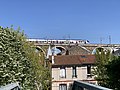
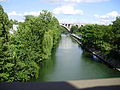
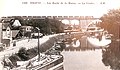
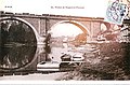
English: The railway bridge of Nogent-sur-Marne is in the Val-de-Marne department (Île-de-France region). It is used by trains to cross the river Marne. North of this river, it is at the limit of the communes of Nogent-sur-Marne (west side) and Le Perreux-sur-Marne (east side) ; south of this river, it is on the commune of Champigny-sur-Marne.
Français : Le viaduc ferroviaire de Nogent-sur-Marne est situé dans le département du Val-de-Marne (région Île-de-France). Il permet aux trains de franchir la Marne. Il est à la limite des communes de Nogent-sur-Marne (à l'ouest) et du Perreux-sur-Marne (à l'est) au nord de la rivière et sur la commune de Champigny-sur-Marne au sud.
 | |||||
| Upload media | |||||
| Instance of | |||||
|---|---|---|---|---|---|
| Part of | |||||
| Location | Nogent-sur-Marne, Val-de-Marne, Île-de-France, Metropolitan France, France | ||||
| Crosses | |||||
| Heritage designation | |||||
| Length |
| ||||
 | |||||
Media in category "Viaduc ferroviaire de Nogent-sur-Marne"
The following 31 files are in this category, out of 31 total.
-
 Ile de France - panoramio (114).jpg 3,456 × 2,592; 7.5 MB
-
 Ile de France - panoramio (118).jpg 2,592 × 3,456; 6.62 MB
-
 Ile de France - panoramio (119).jpg 3,456 × 2,592; 7.35 MB
-
 Le Perreux-sur-Marne bridge.JPG 4,000 × 3,000; 5.48 MB
-
 NOGENT - Vue panoramique du Viaduc.jpg 1,680 × 1,064; 1.32 MB
-
 Nogent-sur-Marne bridge.JPG 4,000 × 3,000; 5.54 MB
-
 Nogent-sur-Marne viaduct.JPG 4,000 × 3,000; 6.21 MB
-
 Rame SNCF Class B 82500 Viaduc Nogent Nogent Marne 1.jpg 4,032 × 3,024; 4.53 MB
-
 Rame SNCF Class B 82500 Viaduc Nogent Nogent Marne 2.jpg 4,032 × 3,024; 4.83 MB
-

-
 Viaduc de Nogent (IMG 0583).jpg 600 × 399; 83 KB
-
 Viaduc du chemin de fer, Nogent-sur-Marne. PH29066.jpg 4,323 × 4,434; 2.92 MB
-
 Viaduc ferroviaire de Nogent-sur-Marne - panoramio (895).jpg 3,456 × 2,592; 6.12 MB
-
 Viaduc ferroviaire de Nogent-sur-Marne 01.jpg 1,920 × 2,560; 1.19 MB
-
 Viaduc ferroviaire de Nogent-sur-Marne 02.jpg 2,560 × 1,920; 1.25 MB
-
 Viaduc ferroviaire de Nogent-sur-Marne 03.jpg 2,560 × 1,920; 1.27 MB
-
 Viaduc ferroviaire de Nogent-sur-Marne 04.jpg 2,560 × 1,920; 1.27 MB
-
 Viaduc ferroviaire de Nogent-sur-Marne 05-2.jpg 1,533 × 1,422; 1.33 MB
-
 Viaduc ferroviaire de Nogent-sur-Marne 05.jpg 2,560 × 1,920; 1.27 MB
-
 Viaduc ferroviaire de Nogent-sur-Marne 06.jpg 2,560 × 1,920; 1.27 MB
-
 Viaduc Nogent - Nogent-sur-Marne (FR94) - 2023-02-24 - 1.jpg 4,032 × 3,024; 4.16 MB
-
 Viaduc Nogent - Nogent-sur-Marne (FR94) - 2023-02-24 - 2.jpg 4,032 × 3,024; 3.81 MB
-
 Viaduc Nogent - Nogent-sur-Marne (FR94) - 2023-02-24 - 3.jpg 4,032 × 3,024; 3.31 MB
-
 Viaduc Nogent - Nogent-sur-Marne (FR94) - 2023-02-24 - 4.jpg 3,024 × 4,032; 3.88 MB
-
 Viaduc Nogent Marne - Champigny-sur-Marne (FR94) - 2021-02-03 - 1.jpg 4,032 × 3,024; 4.71 MB
-
 Viaduc Nogent vu depuis Pont Nogent Marne - Nogent-sur-Marne (FR94) - 2021-02-19 - 1.jpg 4,032 × 3,024; 4.03 MB
-
 Viaduc Nogent.jpg 4,032 × 3,024; 2.52 MB
-
 Viaduc-de-Nogent - CP0771.jpg 3,377 × 1,979; 3.19 MB
-
 Viaduc-de-Nogent - CP0801.jpg 3,493 × 2,122; 3.38 MB
-
 Viaduc-de-Nogent - CP0802.jpg 3,496 × 2,308; 3.83 MB
-
 Viaduc-de-Nogent - CP0803.jpg 3,462 × 2,093; 3.63 MB
.jpg)
.jpg)
.jpg)


.jpg)

.jpg)


_-_2023-02-24_-_1.jpg)
_-_2023-02-24_-_2.jpg)
_-_2023-02-24_-_3.jpg)
_-_2023-02-24_-_4.jpg)
_-_2021-02-03_-_1.jpg)
_-_2021-02-19_-_1.jpg)


Categories:
- Railway bridges in Val-de-Marne
- Monuments à l'inventaire in Champigny-sur-Marne
- Bridges in Le Perreux-sur-Marne
- Ligne Paris-Est - Mulhouse-Ville
- Bridges over the Marne river
- Bridges in Nogent-sur-Marne
- Stone arch railway bridges in Val-de-Marne
- Railway viaducts in France
- Monuments à l'inventaire in Nogent-sur-Marne
- Bridges in Champigny-sur-Marne