Category:Villa Laure-Édouard (Capbreton)
Jump to navigation
Jump to search
| Object location | | View all coordinates using: OpenStreetMap |
|---|
Media in category "Villa Laure-Édouard (Capbreton)"
The following 17 files are in this category, out of 17 total.
-
 Griffes de sorcières dans la jardinière A D2312.jpg 2,112 × 2,816; 1.87 MB
-
 Griffes de sorcières dans la jardinière A D2404.jpg 2,112 × 2,816; 2.18 MB
-
 Griffes de sorcières dans la jardinière B D2404.jpg 2,112 × 2,816; 2.13 MB
-
 Joubarbe dans une jardinière D2312.jpg 2,816 × 2,112; 1.8 MB
-
 Lagures à Capbreton (Landes) 1.jpg 2,816 × 2,112; 2.68 MB
-
 Lagures à Capbreton (Landes) 2.jpg 2,816 × 2,112; 1.73 MB
-
 Lagures à Capbreton (Landes) 3.jpg 2,816 × 2,112; 2.67 MB
-
 1932-Laure et Édouard devant la maison de Capbreton.jpg 3,280 × 2,092; 2.19 MB
-
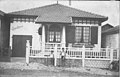
 1969-04 Villa Laure-Édouard (Capbreton).jpg 1,901 × 1,883; 777 KB
-
 Villa Laure Édouard (Capbreton, 1990).jpg 2,117 × 1,386; 1.61 MB
-
 Oxalis et Lagures à Capbreton (Landes) 1.jpg 2,816 × 2,112; 4.17 MB
-
 Oxalis et Lagures à Capbreton (Landes) 2.jpg 2,816 × 2,112; 3.92 MB
-
 Oxalis à Capbreton (Landes) 1.jpg 2,816 × 2,112; 3.09 MB
-
 Paquerettes à Capbreton (Landes).jpg 2,816 × 2,112; 2.9 MB
-
 Petit cèpe dans un jardin de Capbreton.jpg 2,816 × 2,112; 2.87 MB
-
 Rose and white oxalis.jpg 2,816 × 2,112; 3.83 MB
-
 Tristagma uniflorum (Capbreton).jpg 3,468 × 4,624; 3.24 MB


_1.jpg)
_2.jpg)
_3.jpg)

.jpg)
.jpg)
_1.jpg)
_2.jpg)
_1.jpg)
.jpg)


.jpg)