Category:Village hall in Magyarnándor
Jump to navigation
Jump to search
Magyar: A polgármesteri hivatal és Magyarnándor-Cserháthaláp-Debercsény Községek Körjegyzősége.
| Object location | | View all coordinates using: OpenStreetMap |
|---|
Media in category "Village hall in Magyarnándor"
The following 3 files are in this category, out of 3 total.
-
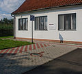 Magyarnándor önkormanyzat parkoló.jpg 1,797 × 1,639; 641 KB
-
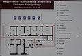 Magyarnándor önkormanyzati épület belső térképe.jpg 2,269 × 1,557; 537 KB
-


