Category:Villages in the Shetland Islands
Jump to navigation
Jump to search
English: Villages in the council area of the Shetland Islands, Scotland.
Wikimedia category | |||||
| Upload media | |||||
| Instance of | |||||
|---|---|---|---|---|---|
| Category combines topics | |||||
| |||||
Subcategories
This category has the following 17 subcategories, out of 17 total.
B
- Biggings, Foula (7 F)
- Biggings, Papa Stour (8 F)
- Bridge End, Shetland Islands (19 F)
H
N
- Nesting, Shetland Islands (2 F)
P
- Papil, West Burra (4 F)
S
- Stonybreck (2 F)
- Symbister, East Burra (18 F)
T
U
V
Media in category "Villages in the Shetland Islands"
The following 24 files are in this category, out of 24 total.
-
 Community hall at Laxfirth - geograph.org.uk - 1307661.jpg 640 × 481; 120 KB
-
 Da Booth - geograph.org.uk - 993453.jpg 640 × 541; 110 KB
-
 Easthouse Byre - geograph.org.uk - 1305420.jpg 640 × 427; 64 KB
-
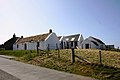
 Easthouse Cottage - geograph.org.uk - 1305414.jpg 640 × 427; 66 KB
-
 Easthouse Croft - geograph.org.uk - 1305426.jpg 640 × 427; 57 KB
-
 FMIB 37045 Peche du Hareng - le Triage du poisson, aux Iles Shetland.jpeg 1,003 × 779; 316 KB
-
 Geosetter, near Bigton - geograph.org.uk - 1463605.jpg 640 × 426; 62 KB
-
 Hamnavoe, Burra - geograph.org.uk - 1337748.jpg 640 × 481; 100 KB
-
 Hoswick from Stove - geograph.org.uk - 1702585.jpg 800 × 534; 194 KB
-
 Houb at the head of Whiteness Voe - geograph.org.uk - 578208.jpg 640 × 426; 63 KB
-
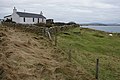
 House by Mousa Ness - geograph.org.uk - 1310855.jpg 640 × 481; 115 KB
-
 Houses and postbox in Twageos Road - geograph.org.uk - 960770.jpg 640 × 480; 84 KB
-
 Houses at Breiwick - geograph.org.uk - 1065028.jpg 640 × 426; 103 KB
-
 Houses at Newgord, Westing - geograph.org.uk - 1322254.jpg 640 × 426; 85 KB
-
 Houses at Toogs - geograph.org.uk - 1061079.jpg 640 × 480; 71 KB
-
 Houses at Wester Quarff - geograph.org.uk - 1180660.jpg 640 × 426; 67 KB
-
 Houses near Stebbigrind, from Hogaland - geograph.org.uk - 1779804.jpg 1,600 × 1,200; 411 KB
-
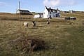 Inquisitive tups, Mid Yell - geograph.org.uk - 764415.jpg 640 × 426; 108 KB
-
 Isleview, Sandwick - geograph.org.uk - 1701019.jpg 800 × 534; 200 KB
-
 Loch of Hellister - geograph.org.uk - 632777.jpg 640 × 480; 36 KB
-
 Snowy Busta IMG 2769 (11293039036).jpg 4,264 × 2,473; 4.26 MB
-
 Dalsetter - geograph.org.uk - 630215.jpg 640 × 426; 91 KB
-
 Houses at Brune - geograph.org.uk - 727236.jpg 640 × 426; 96 KB
-
 Mossbank - geograph.org.uk - 572999.jpg 640 × 426; 43 KB


.jpg)


