Category:Vischmarkt 27, Harderwijk
Jump to navigation
Jump to search
| Object location | | View all coordinates using: OpenStreetMap |
|---|
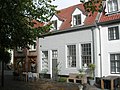
building in Harderwijk, Netherlands  | |||||
| Upload media | |||||
| Instance of | |||||
|---|---|---|---|---|---|
| Location | Harderwijk, Gelderland, Netherlands | ||||
| Street address |
| ||||
| Located on street | |||||
| Heritage designation |
| ||||
 | |||||
|
This is a category about rijksmonument number 20229
|
| Address |
|
Media in category "Vischmarkt 27, Harderwijk"
The following 5 files are in this category, out of 5 total.
-
 Binnenstad, 3841 Harderwijk, Netherlands - panoramio (115).jpg 4,896 × 3,264; 2.84 MB
-
 Binnenstad, 3841 Harderwijk, Netherlands - panoramio (18).jpg 2,048 × 1,148; 605 KB
-
 Binnenstad, 3841 Harderwijk, Netherlands - panoramio (99).jpg 2,048 × 1,155; 559 KB
-
 Harderwijk Vischmarkt 27.JPG 2,592 × 1,944; 1.48 MB
-
 Voorgevels - Harderwijk - 20101329 - RCE.jpg 811 × 1,200; 228 KB
.jpg)
.jpg)
.jpg)
