Category:Vlamertinge
Jump to navigation
Jump to search
section of Ypres, Belgium    | |||||
| Upload media | |||||
| Instance of |
| ||||
|---|---|---|---|---|---|
| Location | Ypres, Arrondissement of Ypres, West Flanders, Flemish Region, Belgium | ||||
| Area |
| ||||
| Elevation above sea level |
| ||||
 | |||||
Subcategories
This category has the following 4 subcategories, out of 4 total.
Media in category "Vlamertinge"
The following 11 files are in this category, out of 11 total.
-
 Cyril Henry Barraud-Vlamertinghe from the Southwest (CWM 19710261-0033).jpeg 5,710 × 3,917; 3.18 MB
-
 Galgebossen Ferraris.jpg 5,472 × 3,648; 23.79 MB
-
 Hop Store Cemetery - Former Hop Store.jpg 981 × 1,512; 1.44 MB
-
 Sixplein, Vlamertinghe, Belgium - Mapillary (QAyRxdisjqkWzPUKyVSCDg).jpg 1,952 × 1,351; 289 KB
-
 The bar at the New Zealand Field Artillery officers' club, World War I (21639934426).jpg 5,122 × 3,736; 3.68 MB
-
 Viamertinghe, 1919.jpg 2,274 × 1,428; 2.51 MB
-
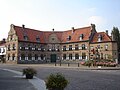 Vlamertinge - Gemeentehuis 1.jpg 2,304 × 1,728; 1.76 MB
-
 Vlamertinge wapen.svg 182 × 290; 153 KB
-
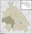 VlamertingeLocation.svg 1,760 × 1,885; 134 KB
-
 Vlamertinghe (Ypres area), destroyed church (19704243578).jpg 5,996 × 4,769; 2.29 MB
-
 Watertoren Dikkebusweg Ieper.jpg 1,552 × 2,592; 888 KB
.jpeg)


.jpg)
.jpg)

,_destroyed_church_(19704243578).jpg)
