Category:Vloeddijk 136, Kampen
Jump to navigation
Jump to search
| Object location | | View all coordinates using: OpenStreetMap |
|---|
.JPG) | |||||
| Upload media | |||||
| Instance of |
| ||||
|---|---|---|---|---|---|
| Location | Kampen, Overijssel, Netherlands | ||||
| Heritage designation |
| ||||
 | |||||
|
This is a category about rijksmonument number 23341
|
| Address |
|
Media in category "Vloeddijk 136, Kampen"
The following 14 files are in this category, out of 14 total.
-
 Achtergevel - Kampen - 20123548 - RCE.jpg 1,197 × 1,200; 417 KB
-
 Deur - Kampen - 20123540 - RCE.jpg 1,188 × 1,200; 205 KB
-
 Interieur bedstede 1e verdieping? - Kampen - 20123557 - RCE.jpg 1,197 × 1,200; 190 KB
-
 Interieur bedstede begane grond - Kampen - 20123552 - RCE.jpg 1,190 × 1,200; 187 KB
-
 Interieur kamer met bedstede 1e verdieping - Kampen - 20123556 - RCE.jpg 1,197 × 1,200; 228 KB
-
 Interieur keuken - Kampen - 20123553 - RCE.jpg 1,190 × 1,200; 218 KB
-
 Interieur keuken - Kampen - 20123554 - RCE.jpg 1,193 × 1,200; 235 KB
-
 Interieur keuken met schouw - Kampen - 20123555 - RCE.jpg 1,190 × 1,200; 247 KB
-
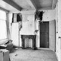
 Interieur schouw achterkamer begane grond - Kampen - 20123550 - RCE.jpg 1,197 × 1,200; 278 KB
-
 Interieur schouw achterkamer begane grond - Kampen - 20123551 - RCE.jpg 1,195 × 1,200; 277 KB
-
 Interieur schouw voorkamer begane grond - Kampen - 20123549 - RCE.jpg 1,195 × 1,200; 216 KB
-
 Interieur zolder achterzijde - Kampen - 20123558 - RCE.jpg 1,200 × 1,200; 316 KB
-
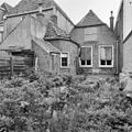
 Kampen rijksmonument (231).JPG 1,944 × 2,592; 1.67 MB
-
 Kampen rijksmonument (232).JPG 1,944 × 2,592; 1.14 MB


.JPG)