Category:Vlooswijk (Woerden)
Jump to navigation
Jump to search
| Object location | | View all coordinates using: OpenStreetMap |
|---|
 | |||||
| Upload media | |||||
| Instance of | |||||
|---|---|---|---|---|---|
| Location | Woerden, Utrecht, Netherlands | ||||
| Street address |
| ||||
| Located on street | |||||
| Heritage designation |
| ||||
 | |||||
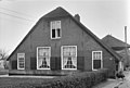
Nederlands: Boerderij Vlooswijk
|
This is a category about rijksmonument number 25995
|
| Address |
|
Subcategories
This category has only the following subcategory.
G
Media in category "Vlooswijk (Woerden)"
The following 5 files are in this category, out of 5 total.
-
 Boerderij met pijlers - Linschoten - 20140615 - RCE.jpg 1,200 × 952; 249 KB
-
 Vlooswijk", aanzicht - Polanen - 20182634 - RCE.jpg 1,200 × 812; 205 KB
-
 Voorgevel - Linschoten - 20140616 - RCE.jpg 1,200 × 953; 287 KB
-
 Zij-achtergevel - Linschoten - 20140618 - RCE.jpg 1,200 × 962; 249 KB
-
 Zijgevel - Linschoten - 20140617 - RCE.jpg 1,200 × 960; 297 KB


