Category:Volksschule Weng
Jump to navigation
Jump to search
| Object location | | View all coordinates using: OpenStreetMap |
|---|
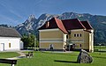
building in Admont, Austria  | |||||
| Upload media | |||||
| Instance of | |||||
|---|---|---|---|---|---|
| Location | Admont, Liezen District, Styria, Austria | ||||
| Street address |
| ||||
| Heritage designation | |||||
 | |||||
Deutsch: Volksschule Weng im Gesäuse, seit 2015 Gemeinde Admont.
Media in category "Volksschule Weng"
The following 4 files are in this category, out of 4 total.
-
 Volksschule Weng 01.jpg 4,664 × 3,174; 7.51 MB
-
 Volksschule Weng 02.jpg 3,850 × 3,156; 5.65 MB
-
 Volksschule Weng 03.jpg 4,745 × 2,949; 6.7 MB
-
 Weng Gesäuse Volksschule.JPG 3,869 × 2,527; 3.01 MB


