Category:Voorstraat 17, Sommelsdijk
Jump to navigation
Jump to search
| Object location | | View all coordinates using: OpenStreetMap |
|---|
building in Goeree-Overflakkee, Netherlands  | |||||
| Upload media | |||||
| Instance of | |||||
|---|---|---|---|---|---|
| Location | Sommelsdijk, South Holland, Netherlands | ||||
| Street address |
| ||||
| Located on street |
| ||||
| Heritage designation |
| ||||
 | |||||
|
This is a category about rijksmonument number 29852
|
| Address |
|
Media in category "Voorstraat 17, Sommelsdijk"
The following 8 files are in this category, out of 8 total.
-
 Exterieur ACHTERGEVEL - Sommelsdijk - 20294522 - RCE.jpg 1,190 × 1,200; 422 KB
-
 Exterieur VOORGEVEL - Sommelsdijk - 20294529 - RCE.jpg 1,185 × 1,200; 329 KB
-
 Exterieur VOORGEVEL MET AANBOUW - Sommelsdijk - 20294521 - RCE.jpg 1,197 × 1,200; 320 KB
-
 INTERIEUR, SCHOUW - Sommelsdijk - 20294524 - RCE.jpg 1,188 × 1,200; 193 KB
-
 INTERIEUR, TRAP IN GANG - Sommelsdijk - 20294523 - RCE.jpg 1,195 × 1,200; 236 KB
-
 Overzicht - Sommelsdijk - 20202777 - RCE.jpg 1,200 × 807; 269 KB
-
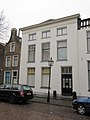 RM29852 Sommelsdijk - Voorstraat 17.jpg 1,944 × 2,592; 999 KB
-
 Voorgevel - Sommelsdijk - 20202789 - RCE.jpg 1,200 × 807; 214 KB


