Category:Voorstraat 17, Vreeland
Jump to navigation
Jump to search
| Object location | | View all coordinates using: OpenStreetMap |
|---|
building in Stichtse Vecht, Netherlands  | |||||
| Upload media | |||||
| Instance of | |||||
|---|---|---|---|---|---|
| Location | Vreeland, Utrecht, Netherlands | ||||
| Street address |
| ||||
| Located on street |
| ||||
| Heritage designation |
| ||||
 | |||||
|
This is a category about rijksmonument number 26158
|
| Address |
|
Media in category "Voorstraat 17, Vreeland"
The following 6 files are in this category, out of 6 total.
-

-
 Hekjes langs voortuinen - Vreeland - 20247278 - RCE.jpg 1,195 × 1,200; 449 KB
-
 Overzicht - Vreeland - 20247251 - RCE.jpg 1,200 × 804; 235 KB
-
 Voorgevel - Vreeland - 20247277 - RCE.jpg 805 × 1,200; 270 KB
-
 Vreeland - Gevelsteen Voorstraat 17 RM26158.JPG 2,670 × 2,190; 603 KB
-
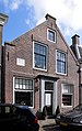 Vreeland - Voorstraat 17 RM26158.JPG 2,841 × 4,524; 1.45 MB


