Category:Voorstreek 113 (Sloten, Friesland)
Jump to navigation
Jump to search
| Object location | | View all coordinates using: OpenStreetMap |
|---|
building in Gaasterlân-Sleat, Netherlands  | |||||
| Upload media | |||||
| Instance of | |||||
|---|---|---|---|---|---|
| Location | Sloten, De Fryske Marren, Friesland, Netherlands | ||||
| Street address |
| ||||
| Located on street | |||||
| Heritage designation |
| ||||
 | |||||
|
This is a category about rijksmonument number 33870
|
| Address |
|
Media in category "Voorstreek 113 (Sloten, Friesland)"
The following 2 files are in this category, out of 2 total.
-
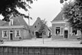 Gevels - Sloten - 20201216 - RCE.jpg 1,200 × 803; 191 KB
-
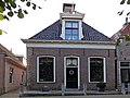 Voorstreek113 Sloten.jpg 3,648 × 2,736; 754 KB
