Category:War memorial Oosterhout
Jump to navigation
Jump to search
| Object location | | View all coordinates using: OpenStreetMap |
|---|
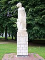
Nederlands: Afbeeldingen van het oorlogsmonument in het Slotpark in Oosterhout in de provincie Noord-Brabant in het zuiden van Nederland
|
This is a category about a war memorial in the Netherlands, number: 712
|
war memorial in Oosterhout, Netherlands _van_Jacques_van_Poppel_-_1.jpg) | |||||
| Upload media | |||||
| Instance of | |||||
|---|---|---|---|---|---|
| Genre | |||||
| Location | Oosterhout, North Brabant, Netherlands | ||||
| Street address |
| ||||
| Creator | |||||
| Inception |
| ||||
| Date of official opening |
| ||||
 | |||||
Media in category "War memorial Oosterhout"
The following 3 files are in this category, out of 3 total.
-
 Oosterhout - Oorlogsmonument (1955) van Jacques van Poppel - 1.jpg 851 × 1,133; 280 KB
-
 Oosterhout - Oorlogsmonument (1955) van Jacques van Poppel - 2.jpg 851 × 1,133; 237 KB
-
 Oosterhout herinneringsmonument oosterhout.jpg 1,768 × 701; 586 KB
_van_Jacques_van_Poppel_-_2.jpg)