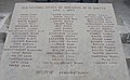
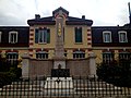
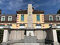
Category:War memorial of Saint-Rambert-en-Bugey
Jump to navigation
Jump to search
| Object location | | View all coordinates using: OpenStreetMap |
|---|
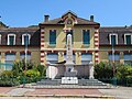
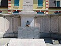
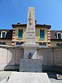
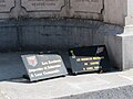
war memorial located in Ain department, France .jpg) | |||||
| Upload media | |||||
| Instance of | |||||
|---|---|---|---|---|---|
| Location | Saint-Rambert-en-Bugey, Ain, Auvergne-Rhône-Alpes, Metropolitan France, France | ||||
| Inception |
| ||||
 | |||||
Media in category "War memorial of Saint-Rambert-en-Bugey"
The following 34 files are in this category, out of 34 total.
-
 Groupe scolaire Claude Guichard St Rambert Bugey 7.jpg 7,425 × 2,099; 16.06 MB
-
 Groupe scolaire Claude Guichard St Rambert Bugey 8.jpg 4,032 × 3,024; 4.64 MB
-
 Monument aux morts - St-Rambert-en-Bugey - 01.jpg 5,184 × 3,888; 5.37 MB
-
 Monument aux morts - St-Rambert-en-Bugey - 02.jpg 5,184 × 3,888; 5.77 MB
-
 Monument aux morts - St-Rambert-en-Bugey - 03.jpg 5,184 × 3,888; 5.66 MB
-
 Monument aux morts - St-Rambert-en-Bugey - 04.jpg 5,184 × 3,888; 6.2 MB
-
 Monument aux morts - St-Rambert-en-Bugey - 05.jpg 5,184 × 3,888; 5.39 MB
-
 Monument aux morts - St-Rambert-en-Bugey - 06.jpg 5,184 × 3,888; 4.86 MB
-
 Monument aux morts - St-Rambert-en-Bugey - 07.jpg 5,184 × 3,888; 5.35 MB
-
 Monument aux morts - St-Rambert-en-Bugey - 08.jpg 3,888 × 5,184; 4.47 MB
-
 Monument aux morts - St-Rambert-en-Bugey - 09.jpg 5,184 × 3,888; 6.06 MB
-
 Monument aux morts - St-Rambert-en-Bugey - 10.jpg 5,184 × 3,888; 4.43 MB
-
 Monument aux morts - St-Rambert-en-Bugey - 11.jpg 3,888 × 5,184; 4.87 MB
-
 Monument aux morts - St-Rambert-en-Bugey - 12.jpg 3,888 × 5,184; 4.68 MB
-
 Monument aux morts de Saint-Rambert-en-Bugey (octobre 2019).jpg 3,024 × 2,728; 5.26 MB
-
 Monument aux morts de Saint-Rambert-en-Bugey 01.JPG 2,304 × 3,072; 3.19 MB
-
 Monument aux morts de Saint-Rambert-en-Bugey 02.JPG 2,304 × 3,072; 3.19 MB
-
 Monument aux morts de Saint-Rambert-en-Bugey 03.JPG 2,304 × 3,072; 2.84 MB
-
 Monument aux morts de Saint-Rambert-en-Bugey 04.JPG 2,304 × 3,072; 3.21 MB
-
 Monument aux morts de Saint-Rambert-en-Bugey 05.JPG 3,072 × 2,304; 3.12 MB
-
 Monument aux morts de Saint-Rambert-en-Bugey 06.JPG 2,952 × 1,830; 2.1 MB
-
 Monument aux morts de Saint-Rambert-en-Bugey.JPG 3,264 × 2,448; 2.14 MB
-
 Monument morts St Rambert Bugey 1.jpg 4,032 × 3,024; 3.77 MB
-
 Monument morts St Rambert Bugey 10.jpg 4,032 × 3,024; 5.59 MB
-
 Monument morts St Rambert Bugey 11.jpg 3,024 × 4,032; 4.99 MB
-
 Monument morts St Rambert Bugey 12.jpg 3,024 × 4,032; 4.17 MB
-
 Monument morts St Rambert Bugey 2.jpg 4,032 × 3,024; 5.26 MB
-
 Monument morts St Rambert Bugey 3.jpg 4,032 × 3,024; 6.45 MB
-
 Monument morts St Rambert Bugey 4.jpg 4,032 × 3,024; 5.03 MB
-
 Monument morts St Rambert Bugey 5.jpg 3,024 × 4,032; 4.11 MB
-
 Monument morts St Rambert Bugey 6.jpg 4,032 × 3,024; 5.79 MB
-
 Monument morts St Rambert Bugey 7.jpg 4,032 × 3,024; 5.02 MB
-
 Monument morts St Rambert Bugey 8.jpg 4,032 × 3,024; 4.92 MB
-
 Monument morts St Rambert Bugey 9.jpg 4,032 × 3,024; 4.67 MB


