Category:Warburton Highway
Jump to navigation
Jump to search
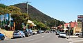
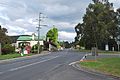
English: Warburton Highway is a 35 kilometre west-east highway starting on the eastern fringes of Melbourne, Victoria at the Maroondah Highway just after Lilydale, connecting Melbourne to the Yarra Valley wine region and its towns. The entire road is within the Shire of Yarra Ranges local government area. It is a single carriageway for its entire length and was completely sealed in 1941.
highway in Victoria  | |||||
| Upload media | |||||
| Instance of | |||||
|---|---|---|---|---|---|
| Location | Victoria, AUS | ||||
| Length |
| ||||
 | |||||
Media in category "Warburton Highway"
The following 6 files are in this category, out of 6 total.
-
 Launching Place, Victoria.jpg 3,664 × 2,062; 1.26 MB
-
 Warburton Main Street.jpg 3,888 × 2,035; 1.52 MB
-
 Warburton Warburton Highway 001.JPG 3,872 × 2,592; 4.19 MB
-
 Warburton Warburton Highway 002.JPG 3,872 × 2,592; 3.79 MB
-
 Warburton Warburton Highway 003.JPG 3,536 × 2,500; 3.24 MB
-
 Wesburn Victoria.JPG 3,872 × 2,592; 3.85 MB


