Category:Waterford
Jump to navigation
Jump to search
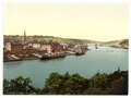
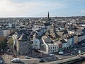
English: Waterford is a city in Ireland. It is located in the South-East Region and is also part of the province of Munster.
Italiano: Waterford è una città di oltre 50.000 abitanti dell'Irlanda sud-orientale, capitale storica dell'omonima contea.
Português: Waterford é uma cidade da República da Irlanda que fica no Condado de Waterford, na província de Munster.
city in the Ireland     | |||||
| Upload media | |||||
| Instance of |
| ||||
|---|---|---|---|---|---|
| Location |
| ||||
| Legislative body |
| ||||
| Executive body |
| ||||
| Population |
| ||||
| Area |
| ||||
| Elevation above sea level |
| ||||
| Different from | |||||
| official website | |||||
 | |||||
Subcategories
This category has the following 18 subcategories, out of 18 total.
B
- Bilberry Goat (6 F)
C
F
- Ferrybank, Waterford (34 F)
H
J
K
N
- Newtown School, Waterford (2 F)
P
S
- Sports in Waterford (4 F)
T
W
- Waterford City walls (5 F)
Pages in category "Waterford"
This category contains only the following page.
Media in category "Waterford"
The following 200 files are in this category, out of 496 total.
(previous page) (next page)-
 Waterford 1714 (Moll).jpg 1,115 × 870; 241 KB
-
 1876 doorway Waterford.jpg 4,320 × 3,240; 5.71 MB
-
 1968 Velorex 16-350 1GFP703-Dashboard.jpg 4,896 × 2,752; 6.07 MB
-

-
 A Message from the Fairies of Magic Wood - geograph.org.uk - 5821614.jpg 800 × 600; 930 KB
-
 A sunny summer Saturday in Waterford - geograph.org.uk - 3748856.jpg 800 × 451; 211 KB
-
 A View across the River Suir - geograph.org.uk - 5822080.jpg 800 × 533; 552 KB
-
 A view of the road bridge across the River Suir - geograph.org.uk - 4607089.jpg 1,477 × 1,201; 426 KB
-
 A-wear, Waterford - geograph.org.uk - 3652324.jpg 640 × 480; 68 KB
-
 Abbey Junction.jpg 2,629 × 1,504; 903 KB
-

-
 Admiralty Chart No 1123 South Coast of Ireland to Lands End, Published 1967.jpg 16,348 × 11,219; 9.13 MB
-
 Admiralty Chart No 2046 Waterford Harbour, Published 1882.jpg 11,126 × 16,238; 70.55 MB
-
 Admiralty Chart No 2049 Ireland south coast Kinsale to Wexford, Published 1890.jpg 14,836 × 8,251; 13.53 MB
-
 AIB bank - geograph.org.uk - 3723631.jpg 2,592 × 1,936; 1.8 MB
-
 AIB Bank, Waterford - geograph.org.uk - 3652366.jpg 640 × 480; 66 KB
-
 Aldi, The Glen, Waterford - geograph.org.uk - 5145963.jpg 2,000 × 1,333; 1.37 MB
-
 Alfie Hale pub by Ballybricken Green - geograph.org.uk - 4685772.jpg 640 × 427; 68 KB
-
 Altar panel, Christ Church Cathedral - geograph.org.uk - 3746684.jpg 600 × 800; 298 KB
-
 American Civil War memorial - geograph.org.uk - 836703.jpg 448 × 640; 64 KB
-
 An award-winning facade - geograph.org.uk - 3530635.jpg 640 × 427; 293 KB
-

-
 Approaching Waterford - geograph.org.uk - 1823440.jpg 640 × 426; 148 KB
-
 Ardoginna House (geograph 4360298).jpg 1,600 × 960; 217 KB
-

-
 Arundel Square, Waterford - geograph.org.uk - 1543089.jpg 480 × 640; 62 KB
-
 Arundel Square, Waterford - geograph.org.uk - 3652251.jpg 640 × 480; 54 KB
-
 Arundel Square, Waterford - geograph.org.uk - 3652349.jpg 640 × 480; 63 KB
-
 Bachelor's Walk, Waterford - geograph.org.uk - 4684437.jpg 640 × 427; 65 KB
-
 Bailey's New Street - geograph.org.uk - 5537025.jpg 480 × 640; 240 KB
-
-
 Ballybricken Green - geograph.org.uk - 5154807.jpg 2,000 × 1,333; 1.17 MB
-
 Ballybricken Green Waterford - geograph.org.uk - 690529.jpg 640 × 480; 45 KB
-
 Ballybricken Green, Waterford - geograph.org.uk - 1483887.jpg 640 × 480; 66 KB
-

-
 Barronstrand Street - geograph.org.uk - 3652368.jpg 640 × 480; 70 KB
-
 Barronstrand Street name sign - geograph.org.uk - 3652370.jpg 640 × 481; 50 KB
-
 Barronstrand Street, Waterford - geograph.org.uk - 3641289.jpg 2,592 × 1,952; 1.03 MB
-
 Beach Tower, Waterford - geograph.org.uk - 4685810.jpg 640 × 427; 82 KB
-

-
 Bike stand, Waterford - geograph.org.uk - 3652357.jpg 640 × 480; 60 KB
-
 Bilberry Road - geograph.org.uk - 5821378.jpg 800 × 600; 601 KB
-
 Bishop's Palace - geograph.org.uk - 5536990.jpg 640 × 480; 274 KB
-
 Blacktie, Waterford - geograph.org.uk - 3652333.jpg 640 × 480; 51 KB
-

-
 Blowing glass, Waterford Crystal Factory - geograph.org.uk - 3652121.jpg 3,240 × 4,320; 4.68 MB
-
 Blue plaque for Thomas Hussey.jpg 1,756 × 1,756; 757 KB
-
 Blue plaque Geoffrey of Waterford.png 1,847 × 1,847; 5 MB
-
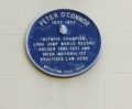 Blue plaque Peter O'Connor.png 1,152 × 954; 1.64 MB
-
 Boats on the river Suir, Waterford (2016).jpg 6,000 × 2,496; 10.29 MB
-
 Boats on the river Suir, Waterford - geograph.org.uk - 1540699.jpg 640 × 443; 58 KB
-
 Boundary marker Tower Ward Waterford.jpg 2,016 × 4,032; 2.87 MB
-
 Bridge at Waterford - geograph.org.uk - 5127698.jpg 2,000 × 1,333; 1.08 MB
-
 Bridge over the N25 near Kilmeadan - geograph.org.uk - 5824912.jpg 800 × 454; 505 KB
-
 Bridge Parapet - geograph.org.uk - 5839568.jpg 800 × 600; 208 KB
-
 Broad Street - geograph.org.uk - 5536323.jpg 640 × 480; 321 KB
-
 Broad Street, Waterford - geograph.org.uk - 1542946.jpg 640 × 480; 89 KB
-
 Broad Street, Waterford - geograph.org.uk - 6443180.jpg 1,802 × 1,201; 418 KB
-
 Buildings on Military Road - geograph.org.uk - 1824336.jpg 640 × 427; 207 KB
-
 Bull Post at Ballybricken in Waterford -155243 (48646807022).jpg 7,952 × 5,304; 26.37 MB
-
 Bull Post at Ballybricken, Waterford -142628 (43689191001).jpg 7,952 × 5,304; 31.11 MB
-

-
 Bus station building - geograph.org.uk - 3510231.jpg 640 × 427; 275 KB
-
 Bus station seats - geograph.org.uk - 3516794.jpg 640 × 427; 518 KB
-
 Bust in Waterford.jpg 896 × 1,200; 175 KB
-
 Car Ferry - geograph.org.uk - 5839550.jpg 800 × 600; 130 KB
-
 Car Park, Waterford - geograph.org.uk - 3652382.jpg 640 × 480; 60 KB
-

-
 Cathedral Square, Waterford - geograph.org.uk - 5145992.jpg 2,000 × 1,333; 1.17 MB
-
 Celebrating 30,000,000 Views (16244689524).png 1,318 × 624; 1.21 MB
-
 Celtic Knot 2024 Blackwater River.png 969 × 728; 1 MB
-
 Celtic Knot 2024 Reginold Tower.png 1,280 × 705; 1.14 MB
-
 Celtic Knot 2024 Waterford.png 640 × 512; 627 KB
-
 Celtic Knot Kisalebeg Church.png 1,280 × 720; 1.38 MB
-
 Celtic Knot River Suir.png 2,560 × 1,065; 4.04 MB
-
 Cemetery of Holy Trinity Church, Waterford - geograph.org.uk - 5145968.jpg 2,000 × 1,333; 1.47 MB
-
 Cemetery of Holy Trinity Church, Waterford - geograph.org.uk - 5154823.jpg 2,000 × 1,333; 1.16 MB
-
 Champagne flute, Waterford Crystal factory - geograph.org.uk - 3652105.jpg 3,240 × 4,320; 4.79 MB
-

-
 Cheekpoint Harbour - geograph.org.uk - 5839614.jpg 800 × 600; 182 KB
-
 Cheekpoint Lime Kiln - geograph.org.uk - 5712310.jpg 3,648 × 2,736; 5.53 MB
-
 Cheekpoint Village - geograph.org.uk - 5712245.jpg 3,648 × 2,736; 2.84 MB
-
 Church in Waterford.jpg 1,200 × 900; 125 KB
-
 City of Waterford - geograph.org.uk - 33684.jpg 640 × 434; 56 KB
-
 Cleaboy Avenue - geograph.org.uk - 3519723.jpg 640 × 427; 283 KB
-
 Clock Tower, Waterford - geograph.org.uk - 3652364.jpg 640 × 480; 45 KB
-
 Clock Tower, Waterford Quay - 154121.jpg 480 × 640; 51 KB
-

-
 Communications Tower - geograph.org.uk - 5840390.jpg 600 × 800; 143 KB
-
 Convent building, Waterford - geograph.org.uk - 3652283.jpg 640 × 480; 61 KB
-
 Corvus frugilegus -Waterford, Ireland-8.jpg 2,017 × 1,345; 1.92 MB
-
 Cotton motorbike January 3, 1930.jpg 2,469 × 1,890; 1.53 MB
-

-
 Crane at the Quay - geograph.org.uk - 1543187.jpg 480 × 640; 61 KB
-
 Crane on Custom House Quay - geograph.org.uk - 5536324.jpg 640 × 480; 256 KB
-
 Crane on the riverfront at Waterford - geograph.org.uk - 6121113.jpg 3,888 × 5,184; 3.55 MB
-
 Customers' Advice - geograph.org.uk - 5840408.jpg 800 × 600; 87 KB
-
 Cycle racks on the Quay - geograph.org.uk - 5537016.jpg 480 × 640; 258 KB
-
 De La Salle College, Waterford - geograph.org.uk - 3530648.jpg 640 × 427; 285 KB
-
 De La Salle Hall, Waterford - geograph.org.uk - 3652343.jpg 640 × 480; 55 KB
-
 Denis o'connor sculpture, Waterford.jpg 7,952 × 5,304; 21.45 MB
-
 DENIS O’CONNOR’S SCULPTURE (GRATTAN QUAY WATERFORD).jpg 5,230 × 5,304; 18.21 MB
-
 Dense Undergrowth - geograph.org.uk - 5839642.jpg 800 × 600; 150 KB
-
 Desciption- Statue of St. Cataldo bishop (Taranto) (Taranto).jpg 343 × 480; 162 KB
-
 Detail showing damage to The Hansa (8660430642).jpg 2,000 × 2,011; 1.84 MB
-
 Dignity - Sunbed Malibu - geograph.org.uk - 3652227.jpg 640 × 480; 58 KB
-
 Doorway with hanging CCTV camera - geograph.org.uk - 3516748.jpg 427 × 640; 320 KB
-
 Dragon Slayer (49158127731).jpg 1,024 × 768; 200 KB
-
 Dry Channel - geograph.org.uk - 5839623.jpg 800 × 600; 99 KB
-
 Dunmore Road - geograph.org.uk - 3510236.jpg 640 × 427; 304 KB
-
 Dunnes Stores, Waterford - geograph.org.uk - 3746735.jpg 800 × 451; 204 KB
-
 Edmund Rice Bridge, Waterford (2016).jpg 6,000 × 4,000; 13.2 MB
-

-
 Entrance and Drive - geograph.org.uk - 5840395.jpg 800 × 600; 138 KB
-
 Entrance and Track - geograph.org.uk - 5839593.jpg 800 × 600; 157 KB
-
 Entrance to Duncannon Fort - geograph.org.uk - 1388536.jpg 640 × 480; 219 KB
-
 Entry of Waterford Crystal Building.jpg 2,272 × 1,704; 1.44 MB
-
 Estatua Waterford.jpg 3,456 × 2,304; 3.3 MB
-
 Estuary View - geograph.org.uk - 5839585.jpg 800 × 600; 141 KB
-
 Estuary View - geograph.org.uk - 5839600.jpg 800 × 600; 103 KB
-

-
 Fairy Houses at Magic Wood - geograph.org.uk - 5821606.jpg 800 × 600; 809 KB
-
 Farronshoneen Roundabout, Waterford - geograph.org.uk - 1476924.jpg 640 × 480; 97 KB
-
 Ferrybank bus, Waterford - geograph.org.uk - 3652383.jpg 640 × 480; 64 KB
-
 Ferrybank church Waterford.jpg 640 × 612; 349 KB
-
 Flyover on the N25 - geograph.org.uk - 5822026.jpg 800 × 600; 904 KB
-
 Forest Entrance - geograph.org.uk - 5839648.jpg 800 × 600; 128 KB
-
 Former harbour office, Waterford - geograph.org.uk - 3059768.jpg 640 × 390; 99 KB
-
 Francis Street - geograph.org.uk - 3510676.jpg 640 × 427; 289 KB
-

-
 Freight yard in Waterford - geograph.org.uk - 6121086.jpg 5,151 × 3,863; 5.04 MB
-
 From east, Waterford. County Waterford, Ireland-LCCN2002717444.tif 3,727 × 2,800; 29.86 MB
-
 From northwest, Waterford. County Waterford, Ireland-LCCN2002717445.tif 3,707 × 2,780; 29.49 MB
-
 Furry Friends (6321342465).jpg 1,235 × 945; 593 KB
-
 Gallery and pottery - geograph.org.uk - 1824327.jpg 640 × 427; 176 KB
-
 Ganoderma curtisii (Berk.) Murrill 794673.jpg 3,024 × 4,032; 3.15 MB
-
 Geoff's Café and Bar, Waterford - geograph.org.uk - 3652166.jpg 640 × 480; 54 KB
-
 Giant chessboard - geograph.org.uk - 5536854.jpg 640 × 480; 342 KB
-
 Gratton Quay-Waterford Greenway - geograph.org.uk - 5821367.jpg 800 × 600; 682 KB
-
 Grayfriar's, Waterford - geograph.org.uk - 5154859.jpg 2,000 × 1,333; 1.46 MB
-
 Green Seat - geograph.org.uk - 5839590.jpg 800 × 600; 182 KB
-

-
 H Samuel, Waterford - geograph.org.uk - 3652327.jpg 640 × 480; 58 KB
-
 Hall's silo, Waterford harbour - geograph.org.uk - 3778409.jpg 640 × 334; 50 KB
-
 Henrietta Walk - geograph.org.uk - 3516735.jpg 427 × 640; 318 KB
-
 Historical remarks of the city of Waterford Fleuron N033583-7.png 840 × 962; 62 KB
-
 Holy Trinity Cathedral, Waterford - geograph.org.uk - 3652359.jpg 640 × 480; 63 KB
-
 Holy Trinity Church, Waterford - geograph.org.uk - 4684443.jpg 640 × 427; 48 KB
-
 House flag of the Waterford Steamship Company.svg 720 × 480; 2 KB
-
 House of Waterford Crystal - geograph.org.uk - 5536852.jpg 640 × 480; 249 KB
-
 House of Waterford Crystal - geograph.org.uk - 5820966.jpg 800 × 533; 510 KB
-
 House on Knockhouse Road, Waterford - geograph.org.uk - 1485457.jpg 640 × 480; 83 KB
-
 Houses at Bilberry - geograph.org.uk - 1823435.jpg 640 × 426; 155 KB
-
 Houses in Avondale Lawn, Waterford - geograph.org.uk - 1475122.jpg 640 × 480; 67 KB
-

-

-
 Hurling Clubhouse - geograph.org.uk - 3519727.jpg 640 × 427; 308 KB
-

-
 Ireland (6018300550).jpg 827 × 627; 190 KB
-

-
 Ireland-Drone-20171017-025 (23910182778).jpg 3,174 × 2,394; 789 KB
-

-

-
 James Gillray, satirical broadside; Surgeons' Bill Wellcome M0010581.jpg 2,650 × 4,248; 3.2 MB
-
 John Condon Memorial -142707 (43764448901).jpg 7,952 × 5,304; 29.3 MB
-
 John Condon Memorial -142708 (43048728894).jpg 7,952 × 5,304; 27.67 MB
-
 John Condon Memorial in Waterford Ireland -142706 (42860548075).jpg 7,952 × 5,304; 34.39 MB
-
 John Moore Plaque - geograph.org.uk - 3579872.jpg 640 × 480; 68 KB
-
 John Roberts blue plaque.jpg 3,672 × 4,896; 6.15 MB
-
 John Roberts Square, Waterford. July 2016.jpg 5,184 × 3,888; 7.14 MB
-
 John Street, Waterford - geograph.org.uk - 3652178.jpg 640 × 480; 55 KB
-
 John's Bridge, Waterford - geograph.org.uk - 5821463.jpg 800 × 600; 711 KB
-
 John's Hill - geograph.org.uk - 3516758.jpg 640 × 640; 514 KB
-
 John's River, Waterford - geograph.org.uk - 5821422.jpg 800 × 600; 1,009 KB
-
 Johns River, Waterford - geograph.org.uk - 3652214.jpg 640 × 480; 52 KB
-
 Katiekim.jpg 579 × 878; 48 KB
-
 Kazbar Bar, Waterford - geograph.org.uk - 3652160.jpg 640 × 480; 57 KB
-
 Keyser sign, Waterford 2.jpg 1,200 × 900; 120 KB
-
 Keyser sign, Waterford.jpg 1,200 × 900; 91 KB
-
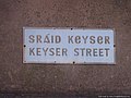
 Keyser Street sign.jpg 3,840 × 2,160; 1.3 MB
-
 Kilcohan Park Greyhound Stadium - geograph.org.uk - 1484067.jpg 621 × 640; 74 KB
-
 Kill St Lawrence, Waterford - geograph.org.uk - 1475667.jpg 640 × 480; 75 KB
-
 Knitted Bicycle - geograph.org.uk - 5839605.jpg 800 × 600; 207 KB
-
 Lady Jane House, Waterford - geograph.org.uk - 3652263.jpg 640 × 480; 60 KB
-
 Lady Jane Street, Waterford - geograph.org.uk - 3652285.jpg 640 × 480; 52 KB
-
 Lady Lane, Waterford - geograph.org.uk - 4684369.jpg 640 × 427; 61 KB
-
 Lidl, off Dunmore Road, Ardkeen, Waterford - geograph.org.uk - 5449526.jpg 1,024 × 655; 106 KB
-
 Lidl, Tramore Road, Waterford - geograph.org.uk - 5449639.jpg 1,024 × 678; 153 KB
-
 Lime Kilns - geograph.org.uk - 5840402.jpg 800 × 600; 170 KB
-

-
 Lorry in Glenville. - commissioned by W. Power & Son, O'Connell Street, Waterford.jpg 2,000 × 1,541; 810 KB
-
 Low Tide - geograph.org.uk - 5839617.jpg 800 × 600; 89 KB
-
 Low Tide and Bridge - geograph.org.uk - 5839611.jpg 800 × 600; 73 KB
-

-

-
 Manor Street, Waterford - geograph.org.uk - 3652238.jpg 640 × 480; 54 KB
-
 Map of Waterford.png 1,506 × 874; 603 KB
-
 Mary Butler constituency office.jpg 4,896 × 3,672; 5.13 MB
-
 Mary Street, Waterford - geograph.org.uk - 5154776.jpg 1,333 × 2,000; 1.43 MB
-

.jpg)


_-_geograph.org.uk_-_6091825.jpg)

.jpg)


.jpg)


.jpg)
.jpg)


.png)


.jpg)

_(Taranto).jpg)
.jpg)


.jpg)


.jpg)


.jpg)

_Murrill_794673.jpg)


.jpg)
.jpg)


.jpg)
.jpg)
.jpg)


