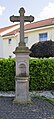
Category:Wegekreuz Bartholomäusweg/Grubenstraße (Leimersdorf)
Jump to navigation
Jump to search
| Object location | | View all coordinates using: OpenStreetMap |
|---|
Media in category "Wegekreuz Bartholomäusweg/Grubenstraße (Leimersdorf)"
The following 2 files are in this category, out of 2 total.
-
 Kreuz Grafschaft001-Leimersdorf-Grubenstr 01.jpg 2,292 × 5,062; 7.63 MB
-
 Kreuz Grafschaft001-Leimersdorf-Grubenstr 02.jpg 3,456 × 5,184; 12.8 MB

